Low Point Convergence
Analysis™
LPCA™ is the proprietary terrain analysis methodology developed by Low Point Labs to model how water naturally moves across residential landscapes.
By analyzing elevation patterns, drainage convergence, watershed behavior, and structure proximity, LPCA™ translates complex topographic data into clear, property-specific drainage interpretations that help homeowners, inspectors, and real estate professionals make informed decisions.
How LPCA™ Works
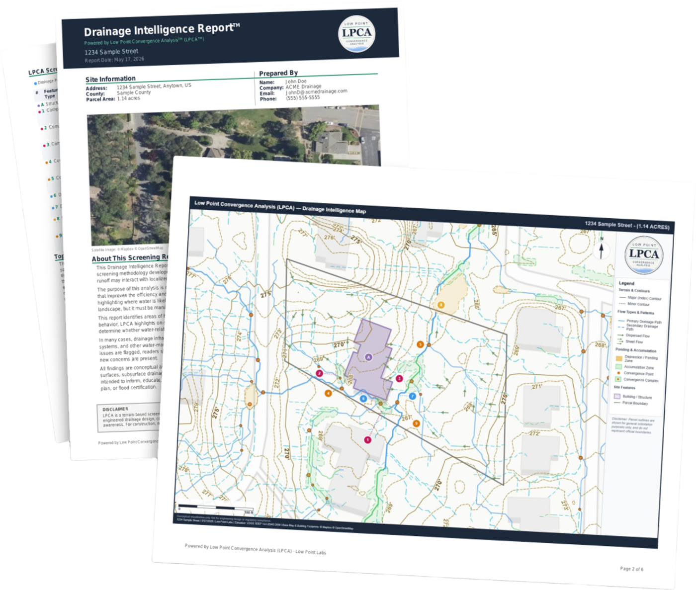
Every Drainage Intelligence Report™ is built on six interconnected analytical pillars. Each pillar contributes a distinct layer of insight, and together they produce a comprehensive picture of how water interacts with a property.
Terrain Slope Modeling
Understanding how gravity drives water
Every property has a unique surface profile shaped by natural topography, grading, and development. LPCA™ uses high-resolution elevation data to model slope gradients across the entire parcel, identifying the steepest descent paths that water follows under gravity. This forms the foundation of all downstream analysis — without understanding slope, you cannot predict flow.
- Uses USGS 3DEP LiDAR elevation data at approximately 1-meter resolution
- Calculates slope magnitude and direction for every grid cell
- Identifies ridgelines and valley lines that define natural drainage divides
- Models how grading around structures redirects natural water movement
Drainage Convergence Mapping
Where individual flow paths come together
Water doesn't move across a property in isolation. As runoff travels downhill, individual flow paths merge and intensify at convergence points. LPCA™ uses D8 flow accumulation algorithms to trace how upstream contributing areas feed into convergence zones — areas where concentrated flow may create erosion risk, saturated soil, or structural concerns.
- D8 flow direction algorithm determines the single steepest-descent neighbor for each cell
- Flow accumulation counts upstream contributing cells to quantify drainage intensity
- Identifies convergence points where multiple flow paths merge
- Classifies drainage features into a four-tier stream hierarchy based on accumulation thresholds
Watershed Pattern Analysis
Context beyond the property line
A property's drainage behavior isn't determined by the parcel alone. Surrounding terrain can direct significant runoff onto or across the site. LPCA™ delineates watershed boundaries to show how much upstream area contributes flow to each drainage feature, giving property owners critical context about off-site water influences.
- Delineates watershed boundaries for each significant drainage feature
- Calculates total upstream contributing area in acres
- Identifies off-site flow sources that may impact the property
- Shows whether drainage patterns originate on-site or from surrounding terrain
Structure Proximity Review
Drainage behavior near what matters most
The relationship between drainage features and structures is often the most consequential finding. LPCA™ evaluates how flow paths, convergence zones, and accumulation areas interact with building footprints — highlighting areas where water behavior may warrant closer inspection or professional evaluation.
- Identifies drainage features within defined proximity buffers of structures
- Evaluates flow direction relative to foundation walls and entry points
- Highlights convergence zones that direct concentrated flow toward buildings
- Assesses ponding potential in areas adjacent to structures
Ponding Potential Assessment
Where water may collect and persist
Topographic depressions — even subtle ones — can trap water and create ponding conditions after rainfall. LPCA™ uses pit-filling analysis to identify depressions in the terrain surface and models likely accumulation zones, providing insight into areas where standing water may develop.
- Pit-filling algorithms detect topographic depressions across the site
- Estimates ponding depth and spatial extent for each depression
- Identifies whether depressions have natural overflow outlets
- Correlates ponding zones with structure proximity and drainage convergence
Environmental Context Integration
Soil, precipitation, and regulatory data
Terrain analysis alone doesn't tell the full story. LPCA™ integrates SSURGO soil survey data, historical precipitation analytics, FEMA flood zone boundaries, and National Wetland Inventory layers to provide environmental context that shapes how terrain-driven drainage behaves in practice.
- SSURGO soil data provides infiltration rates, hydrologic soil groups, and drainage class
- 10-year precipitation analytics from ERA5 climate data inform rainfall context
- FEMA flood zone and NWI wetland overlays add regulatory awareness
- Rational Method runoff calculations combine terrain, soil, and rainfall data
How LPCA™ Becomes Your Report
The six pillars work together in a structured pipeline that transforms raw terrain data into a Drainage Intelligence Report™.
Data Acquisition
High-resolution LiDAR elevation data, parcel boundaries, soil surveys, and climate records are retrieved for the property.
Terrain Processing
Elevation data is processed through pit-filling, slope calculation, flow direction, and accumulation algorithms.
Feature Analysis
Drainage features are classified, clustered by proximity to structures, and organized into a three-tier hierarchy.
Report Generation
AI-powered narrative combines all findings into a clear, property-specific Drainage Intelligence Report™.
Important Limitations
LPCA™ is a terrain-based screening methodology that uses publicly available topographic data to identify areas of potential drainage interest. It is not an engineered drainage design, construction plan, or flood certification.
The analysis cannot account for underground drainage systems, French drains, recently completed grading work, or other improvements not reflected in the elevation data. Flagged areas indicate terrain conditions that may warrant attention — not confirmed problems.
Drainage Intelligence Reports™ are intended for informational purposes and early awareness. For construction, regulatory compliance, or definitive property assessments, always consult a licensed professional engineer.
See LPCA™ in Action
Subscribe to Drainage Intelligence Reports™
Enter any address to check coverage and start your subscription — reports generate on demand.