How Terrain Determines Where Water Will Pool on Your Property
Every rainstorm tells the same story: water falls from the sky, hits the ground, and moves. Where it moves — and more importantly, where it stops — is dictated almost entirely by terrain. Understanding terrain drainage patterns is the single most important factor in predicting where water will pool on your property, whether it threatens your foundation, and what you can do to redirect it before damage occurs.
The relationship between terrain and water is governed by physics. Gravity pulls water downhill along the path of least resistance, and every subtle rise, depression, and slope transition on your property acts as an invisible channel guiding that flow. A two-inch elevation change across your backyard might seem trivial when you're mowing the lawn, but during a heavy rain event, that two inches is the difference between water draining safely to the street and water collecting against your foundation wall. In this guide, we'll break down exactly how terrain controls water movement, how to read your landscape for drainage risk, and what tools and techniques can help you take control of your property's hydrology.
The Physics of Water Flow Across Terrain
Water obeys one fundamental rule on the surface of the earth: it flows downhill. More precisely, it flows along the steepest available gradient — the direction where elevation drops most rapidly over the shortest horizontal distance. This principle, called the hydraulic gradient, is what transforms your property's terrain into a network of invisible drainage paths.
When rain hits the ground, each droplet begins moving in the direction of steepest descent from its landing point. As individual droplets converge, they form sheet flow — a thin, broad layer of water moving across the surface. Sheet flow is the dominant form of overland drainage on residential properties, and its behavior is controlled entirely by the micro-topography of your yard. Even variations of a fraction of an inch per foot can determine whether sheet flow moves toward the street or toward your house.
As sheet flow concentrates, it transitions into channelized flow — small rivulets and streams that carry greater volumes at higher velocities. These channels form naturally along terrain features called thalwegs, which are the lowest lines running through a valley or depression. On a residential property, a thalweg might be the subtle low line running between two gentle mounds in your backyard, or the swale along the edge of your driveway. Recognizing these natural flow paths is the first step in understanding your property's drainage behavior.
The velocity and volume of surface flow depend on three terrain factors: slope steepness, slope length, and surface roughness. Steeper slopes produce faster flow, longer slopes accumulate more volume, and rougher surfaces (like dense turf) slow water down while smoother surfaces (like compacted clay or concrete) speed it up. The interplay of these factors determines not just where water goes, but how much energy it carries — and therefore how much erosion it can cause along the way.
Get Your Drainage Intelligence Report™
Start a free trial and generate reports on demand.
How Contour Lines Reveal Drainage Patterns
If you want to understand water pooling terrain analysis at a professional level, you need to learn to read contour lines. Contour lines are the cartographic representation of terrain — each line connects points of equal elevation, and the spacing between lines tells you how steep the ground is. Close-together contour lines mean steep terrain; widely spaced lines mean gentle slopes or flat ground.
On a topographic map of your property, water flows perpendicular to contour lines, always moving from higher elevations to lower ones. By tracing flow paths perpendicular to the contours, you can map exactly where water will travel across your lot. Where contour lines form a V-shape pointing uphill, you're looking at a valley or drainage channel — water converges here. Where contour lines form a V-shape pointing downhill, you're looking at a ridge — water diverges and flows away from this line.
Closed contour loops — concentric rings on a map — reveal two critical terrain features. If the elevation decreases toward the center of the loops, you've found a depression or bowl. This is where water will pool with nowhere to go, creating standing water after every rain event. If the elevation increases toward the center, you've found a hilltop or mound, and water will flow radially outward in all directions.
For residential properties, the most dangerous contour pattern is a closed depression with no outlet. These are the terrain features that create persistent standing water, mosquito breeding habitat, and — if located near your home — chronic foundation moisture problems. Many homeowners don't realize their yard contains a closed depression because the elevation differences involved can be as small as three to six inches. These features are invisible to the naked eye but perfectly legible on a high-resolution topographic survey or digital elevation model.
Modern elevation data, such as that available through the USGS 3D Elevation Program (3DEP), provides LiDAR-derived terrain models with sub-foot accuracy across much of the United States. While this data is invaluable for regional analysis, property-level drainage assessment often requires even higher resolution — which is where professional surveys and specialized tools like those offered by Low Point Labs come into play.
Understanding Watersheds at the Property Scale
Most people associate the word "watershed" with rivers and regional geography, but every property sits within its own micro-watershed — and may contain several smaller ones. A watershed is simply the area of land that drains to a single point. On your property, each low point, drain inlet, or outlet has its own contributing watershed: the area of terrain that funnels water toward it.
Understanding your property-scale watershed is critical because it tells you how much water any given point on your lot has to handle. A low spot in your backyard might only collect rain that falls directly on it — or it might be the collection point for runoff from your entire yard, your neighbor's yard, and a section of the street. The volume of water arriving at that low point is a function of the watershed area, the rainfall intensity, and the percentage of the surface that is impervious (roofs, driveways, patios).
Watershed boundaries on a property are defined by ridgelines — the high points that separate one drainage area from another. Your roofline is a perfect example: rain falling on the north side of your roof flows to the north gutters, and rain on the south side flows to the south gutters. The ridge of the roof is the watershed divide. The same principle applies to your yard, just with much subtler elevation differences. A gentle crown running through the middle of your lawn might divide your property into two distinct drainage areas, each flowing toward a different edge of the lot.
The practical implication is that drainage problems are often caused not by what's happening at the problem spot itself, but by what's happening uphill. If your neighbor regraded their yard, installed a patio, or built an addition, they may have altered the watershed boundary and redirected water onto your property. Similarly, if a new development uphill increased impervious surface coverage, your property may now be receiving significantly more runoff than it was designed to handle — even though your own terrain hasn't changed.
Calculating Contributing Area
To estimate how much water a low point will collect, you need to know the contributing watershed area and the design rainfall intensity for your region. A simple calculation uses the Rational Method: Q = CiA, where Q is the peak flow rate, C is the runoff coefficient (ranging from 0.1 for sandy open land to 0.95 for impervious surfaces), i is the rainfall intensity in inches per hour, and A is the contributing area in acres.
For a typical residential lot, even a small contributing area can produce surprising volumes. Consider a 5,000-square-foot section of lawn (about 0.11 acres) with a runoff coefficient of 0.35 during a 2-inch-per-hour rainfall event. The peak flow rate would be approximately 0.08 cubic feet per second — which translates to roughly 36 gallons per minute flowing toward the low point. If that low point has no outlet, water accumulates rapidly.
The Role of Adjacent Properties
Terrain doesn't respect property lines. One of the most common sources of drainage problems is water flowing onto a property from adjacent lots, roads, or uphill developments. In many jurisdictions, there are legal doctrines governing surface water drainage between properties — such as the "reasonable use" rule, which holds that a property owner cannot substantially alter natural drainage patterns in a way that damages neighboring properties.
Understanding the broader terrain context around your property is essential for diagnosing drainage issues. A property that appears to have adequate slope when viewed in isolation may actually sit at the bottom of a much larger drainage area that funnels water from multiple surrounding lots.
Terrain Features That Cause Water Pooling
Not all terrain creates drainage problems. Specific landform features are responsible for the vast majority of residential water pooling issues. Learning to identify these features — even when they're subtle — is the key to proactive drainage management.
Closed Depressions and Bowls
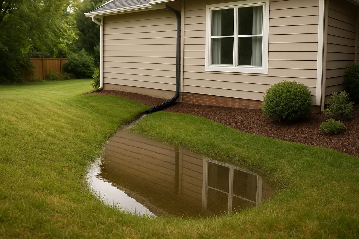
The most obvious pooling feature is a closed depression — a low area surrounded on all sides by higher ground with no surface outlet. Water flows in from all directions and has nowhere to go except down into the soil. If the soil has low permeability (clay-heavy soils, compacted fill, or areas with a high water table), the depression fills up and holds standing water for hours, days, or even weeks after a rain event.
Closed depressions on residential properties are often created unintentionally during construction. Backfill around foundations settles over time, creating a bowl shape right next to the house. Poorly planned landscaping berms can trap water behind them. Even the natural settling of fill material in a graded yard can produce depressions that weren't in the original grading plan.
Flat Areas and Slope Transitions
Perfectly flat terrain is almost as problematic as a depression. Water needs slope to move, and the minimum recommended slope for effective surface drainage is 2% (a drop of about 2.5 inches over 10 feet). Areas with slopes below 1% will drain very slowly, allowing water to spread out and linger on the surface. This is particularly common in backyards where builders graded just enough slope to pass inspection, only to have settling and soil compaction reduce the effective grade over time.
Slope transitions — places where steep terrain flattens out — are another common pooling location. Water moving quickly down a slope suddenly decelerates when it reaches flatter ground, causing it to spread out and accumulate. This is the same principle that creates alluvial fans at the base of mountains, just at a much smaller scale. On a residential property, this often manifests as a soggy band of lawn where the yard transitions from a sloped section to a flat area near the property line.
Convergence Zones
Where two slopes meet at a valley or swale, water from both slopes converges into a single flow path. These convergence zones handle disproportionately large volumes of water relative to their size, and they're prone to erosion, saturation, and overflow. If a convergence zone leads to a constriction — such as a narrow gap between a fence and a building, or a culvert that's too small — water backs up and pools upstream of the bottleneck.
On residential properties, convergence zones commonly form between houses in subdivisions, along the edges of driveways, and at the junction of backyard slopes. These are often the locations where homeowners first notice drainage problems, because the concentrated flow is visible and the pooling is obvious.
Obstructed Flow Paths
Terrain may provide a perfectly adequate drainage path, but human-made obstructions can block it. Fences with solid bases, retaining walls without weep holes, raised garden beds, and even dense hedge rows can act as dams, trapping water on the uphill side. The terrain analysis might show a clear flow path from your yard to the street, but if there's a six-inch concrete curb with no break in it, water will pool behind that curb until it finds another way around — or rises high enough to overflow.
Land Slope Drainage: Measuring and Interpreting Grade
The concept of land slope drainage is deceptively simple — water flows downhill — but the details matter enormously. The slope of your terrain determines not just the direction of flow, but the velocity, the volume that can be conveyed, and the likelihood of erosion or pooling.
How Slope Is Measured
Slope is expressed as a percentage, a ratio, or an angle. For residential drainage work, percentage is the most common and practical unit. A 2% slope means the ground drops 2 feet for every 100 feet of horizontal distance — or equivalently, about 1/4 inch per foot. Here are the key slope benchmarks for residential drainage:
- Less than 1% slope: Effectively flat. Water will not drain reliably. Pooling is likely, especially on clay soils or compacted ground.
- 1% to 2% slope: Marginal drainage. May work on sandy, permeable soils but is insufficient for clay soils or areas with heavy runoff.
- 2% to 5% slope: The ideal range for residential lawn drainage. Provides reliable sheet flow without excessive erosion risk.
- 5% to 10% slope: Adequate drainage but increasing erosion risk, especially on bare soil. Turf or ground cover is important for stabilization.
- Greater than 10% slope: Steep enough to require erosion control measures. Drainage is rapid but may cause scour, channel formation, and sediment transport.
The critical number for foundation protection is the slope within the first 10 feet around your home. Building codes and best practices typically require a minimum of 6 inches of fall within the first 10 feet away from the foundation — that's a 5% slope. This ensures that water hitting the ground near the foundation moves away quickly before it can infiltrate the soil and reach the foundation wall or footing drain.
Measuring Slope at Home
Homeowners can measure slope with basic tools. The simplest method uses a long straight board (8 to 10 feet), a level, and a tape measure. Place one end of the board against the foundation wall, level it, and measure the gap between the far end of the board and the ground. If the gap is 5 inches over a 10-foot board, you have a 4.2% slope — close to the recommended minimum but potentially insufficient after accounting for settling.
For more precise measurements, a laser level or transit can establish elevation differences across longer distances. Digital tools and smartphone apps can provide rough slope estimates, but they typically lack the accuracy needed for drainage engineering. Professional surveys using total stations or GPS equipment provide the most reliable data, with accuracies measured in hundredths of a foot.
Compound Slopes and Their Effects
Real terrain rarely has a single, uniform slope. Most residential properties have compound slopes — surfaces that tilt in multiple directions simultaneously. A backyard might slope away from the house (good) while also tilting toward the left side of the property (neutral or problematic, depending on what's on the left). The combination of these two slope components determines the actual flow direction, which is the vector sum of the two gradients.
Compound slopes can create unexpected drainage patterns. A yard that appears to slope away from the house might actually direct water toward a corner of the foundation because the cross-slope component is stronger than the away-from-house component. This is one of the most common findings in professional drainage assessments — the apparent slope direction doesn't match the actual flow direction when both slope components are considered.
Soil, Infiltration, and Their Interaction with Terrain
Terrain determines where water flows on the surface, but soil determines how much water stays on the surface versus soaking into the ground. The interaction between terrain and soil properties is what ultimately determines whether a given location will experience pooling.
Soils are classified into four Hydrologic Soil Groups (A through D) by the Natural Resources Conservation Service (NRCS), based on their infiltration capacity. Group A soils (sands and gravels) absorb water rapidly and rarely produce significant surface runoff. Group D soils (heavy clays and soils with high water tables) absorb water very slowly, and nearly all rainfall becomes surface runoff that must be managed by terrain-driven drainage.
You can look up the soil types on your property using the NRCS Web Soil Survey, which provides detailed soil maps for virtually every property in the United States. Knowing your soil's hydrologic group is essential for understanding how your terrain's drainage patterns will perform in practice.
A property with Group A soils can tolerate flatter terrain and even minor depressions because water infiltrates quickly enough to prevent prolonged pooling. The same terrain with Group D soils would be a drainage disaster — every low point would hold water, every flat area would become saturated, and the lack of infiltration would send large volumes of runoff cascading across the surface toward the lowest point on the lot.
Compaction and Disturbed Soils
New construction dramatically alters soil infiltration capacity. Heavy equipment compacts the soil, reducing pore space and infiltration rates by 70% to 90% in some cases. The thin layer of topsoil spread over compacted subgrade during final grading provides minimal infiltration benefit — water passes through the topsoil quickly and then hits the compacted layer, where it moves laterally along the interface rather than continuing downward.
This means that newly constructed homes are especially vulnerable to terrain-driven pooling. The grading plan may have specified adequate slopes, but the combination of compacted subsoils and minimal topsoil creates conditions where surface runoff is far higher than it would be on undisturbed ground. Settling of fill material then reduces the already-marginal slopes, and within a few years, the homeowner is dealing with standing water in locations that were supposed to drain.
Seasonal Water Table Effects
The water table — the level below which soil is fully saturated — fluctuates seasonally and can dramatically affect surface drainage. During wet seasons, a rising water table reduces the soil's capacity to absorb surface water. In extreme cases, the water table can rise to the surface, creating springs and seeps that add water to the surface flow system regardless of rainfall.
Terrain features that function as adequate drainage during dry seasons may fail during wet seasons when the water table is high. A gentle swale that normally absorbs and conveys runoff effectively might become a saturated, soggy mess when the water table rises to within a few inches of the surface. This seasonal variability is one reason why drainage assessments should consider worst-case conditions rather than average conditions.
Technology and Tools for Terrain Drainage Analysis
Modern technology has transformed our ability to analyze terrain drainage patterns. What once required expensive professional surveys can now be supplemented (though not entirely replaced) by remote sensing data, GIS tools, and computational models.
LiDAR and Digital Elevation Models
LiDAR (Light Detection and Ranging) technology uses laser pulses fired from aircraft to measure ground elevation with remarkable precision — typically 6 to 12 inches of vertical accuracy for publicly available datasets, and sub-inch accuracy for custom surveys. LiDAR data is processed into Digital Elevation Models (DEMs), which are grid-based representations of terrain elevation that can be analyzed computationally.
From a DEM, software can automatically delineate watersheds, trace flow paths, calculate slope and aspect, identify depressions, and estimate flow accumulation — the amount of upstream area draining through each point. Flow accumulation maps are particularly powerful for drainage analysis because they highlight the terrain features that concentrate water, even when those features are too subtle to see with the naked eye.
GIS-Based Flow Analysis
Geographic Information System (GIS) software enables sophisticated terrain drainage analysis that goes far beyond what's possible with manual contour interpretation. Standard GIS workflows for drainage analysis include:
- Filling sinks: Identifying and optionally filling closed depressions in the DEM to create a "hydrologically corrected" surface
- Flow direction: Calculating the direction water will flow from each cell in the grid based on the steepest downhill neighbor
- Flow accumulation: Counting the number of upstream cells that drain through each cell, revealing natural drainage channels and convergence zones
- Watershed delineation: Defining the contributing area for any specified outlet point
- Stream network extraction: Identifying the connected network of drainage channels based on flow accumulation thresholds
These analyses can be performed using open-source tools like QGIS or commercial platforms, and they provide insights that are impossible to obtain through field observation alone. For homeowners and contractors, the results of these analyses can be visualized as maps showing exactly where water will flow and where it will collect.
Low Point Labs' Approach
At Low Point Labs, we combine high-resolution elevation data with proprietary analysis algorithms to produce property-specific drainage intelligence. Our assessments identify every low point, flow path, convergence zone, and contributing watershed on your property — translating complex terrain data into clear, actionable insights about your drainage risk. This level of analysis was previously available only through expensive engineering surveys, but advances in data availability and computational tools have made it accessible to every homeowner.
Practical Solutions: Working With (and Against) Terrain
Once you understand how terrain controls water movement on your property, you can make informed decisions about drainage improvements. The most effective solutions work with the existing terrain rather than fighting it — redirecting water along natural flow paths to safe discharge points rather than trying to eliminate the fundamental physics of gravity-driven flow.
Regrading and Slope Correction
The most direct solution to terrain-driven pooling is regrading — physically reshaping the ground to eliminate depressions and establish adequate slopes. For foundation protection, this means building up soil against the foundation wall and sloping it away at a minimum of 5% (6 inches of fall in 10 feet). For yard drainage, it means filling depressions, smoothing flat spots, and ensuring continuous downhill grades toward appropriate discharge points.
Regrading is most effective when guided by a comprehensive terrain analysis that identifies all the problem areas and their contributing watersheds. Without this analysis, regrading efforts often solve one problem while creating another — filling a depression in one area may redirect water toward a different area that wasn't designed to handle the additional flow.
Swales and Berms
Swales (shallow, vegetated channels) and berms (raised earthen ridges) are terrain modifications that redirect surface flow without the need for pipes or structures. A well-designed swale intercepts sheet flow and channels it along a controlled path to a safe outlet. A berm blocks flow from entering an area and redirects it around the protected zone.
The key to effective swale design is maintaining adequate longitudinal slope (typically 1% to 4%) so water keeps moving rather than pooling in the swale itself. The swale cross-section should be broad and shallow — a gentle parabolic shape rather than a narrow V — to promote sheet flow and infiltration while preventing erosion.
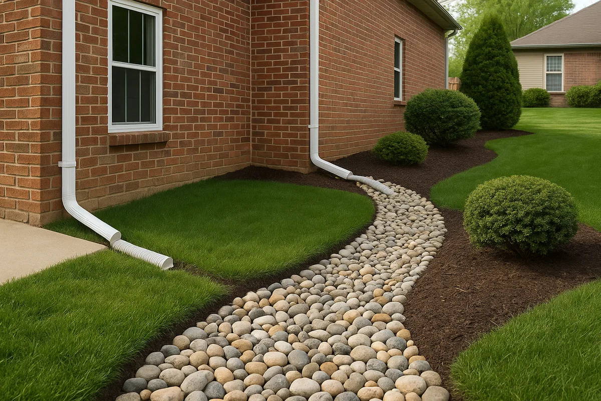
French Drains and Subsurface Systems
When surface regrading isn't feasible — due to space constraints, existing landscaping, or structural limitations — subsurface drainage systems can intercept and redirect water below ground. French drains (perforated pipes surrounded by gravel in a trench) are the most common subsurface solution for residential properties. They work by intercepting groundwater and surface water that infiltrates into the trench, collecting it in the perforated pipe, and conveying it by gravity to a discharge point.
The placement of French drains should be guided by terrain analysis. The drain needs to be located where water naturally converges or where it needs to be intercepted before reaching a problem area. The pipe must maintain a minimum slope of 1% (some codes require 0.5% minimum) to ensure water flows through the system rather than stagnating.
Rain Gardens and Bioretention
In situations where terrain creates a natural collection point that can't easily be eliminated, converting that low point into a rain garden or bioretention area is an elegant solution. These features are intentionally designed depressions filled with engineered soil media and planted with water-tolerant vegetation. They accept and temporarily store runoff, allowing it to infiltrate slowly into the ground rather than pooling on the surface.
Rain gardens work with the terrain rather than against it — they embrace the low point and transform it from a liability into an asset. The key design requirements are an engineered soil mix that promotes infiltration (typically a blend of sand, compost, and topsoil), an overflow outlet for extreme events, and adequate setback from foundations (typically at least 10 feet).
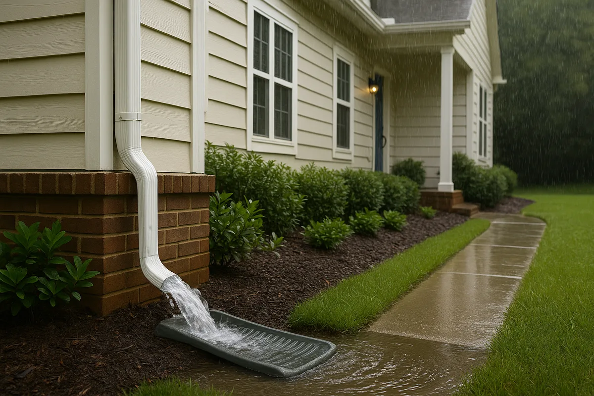
Downspout Management
Roof runoff is one of the largest concentrated water sources on a residential property, and where that water is discharged has a massive impact on drainage patterns. A single downspout on a 500-square-foot roof section produces approximately 310 gallons of runoff per inch of rainfall. If that water is dumped at the base of the foundation, it overwhelms the local terrain's ability to drain it away.
Downspout extensions, underground discharge pipes, and splash blocks should direct roof runoff at least 6 to 10 feet from the foundation — and ideally toward a natural drainage path identified through terrain analysis. Discharging downspouts into a terrain feature that flows away from the house and toward the street or storm drain system is the most effective approach.
Long-Term Monitoring and Terrain Changes
Terrain is not static. Soil settles, erosion reshapes slopes, tree roots alter surface contours, and human activities continuously modify the ground surface. A drainage system that works perfectly today may fail in five years if the underlying terrain changes.
Settling is the most common cause of terrain-related drainage failures over time. Fill material placed during construction compacts under its own weight and under the influence of wetting and drying cycles. This settling is most pronounced in the first 5 to 10 years after construction but can continue for decades. Areas backfilled around foundations, over utility trenches, and over buried construction debris are particularly prone to settling.
Erosion gradually flattens slopes by removing soil from high points and depositing it in low points. On a residential property, this process is accelerated by concentrated runoff from downspouts, driveways, and other impervious surfaces. Over time, erosion can reduce the effective slope of drainage paths below the minimum needed for reliable flow, creating new pooling areas where none existed before.
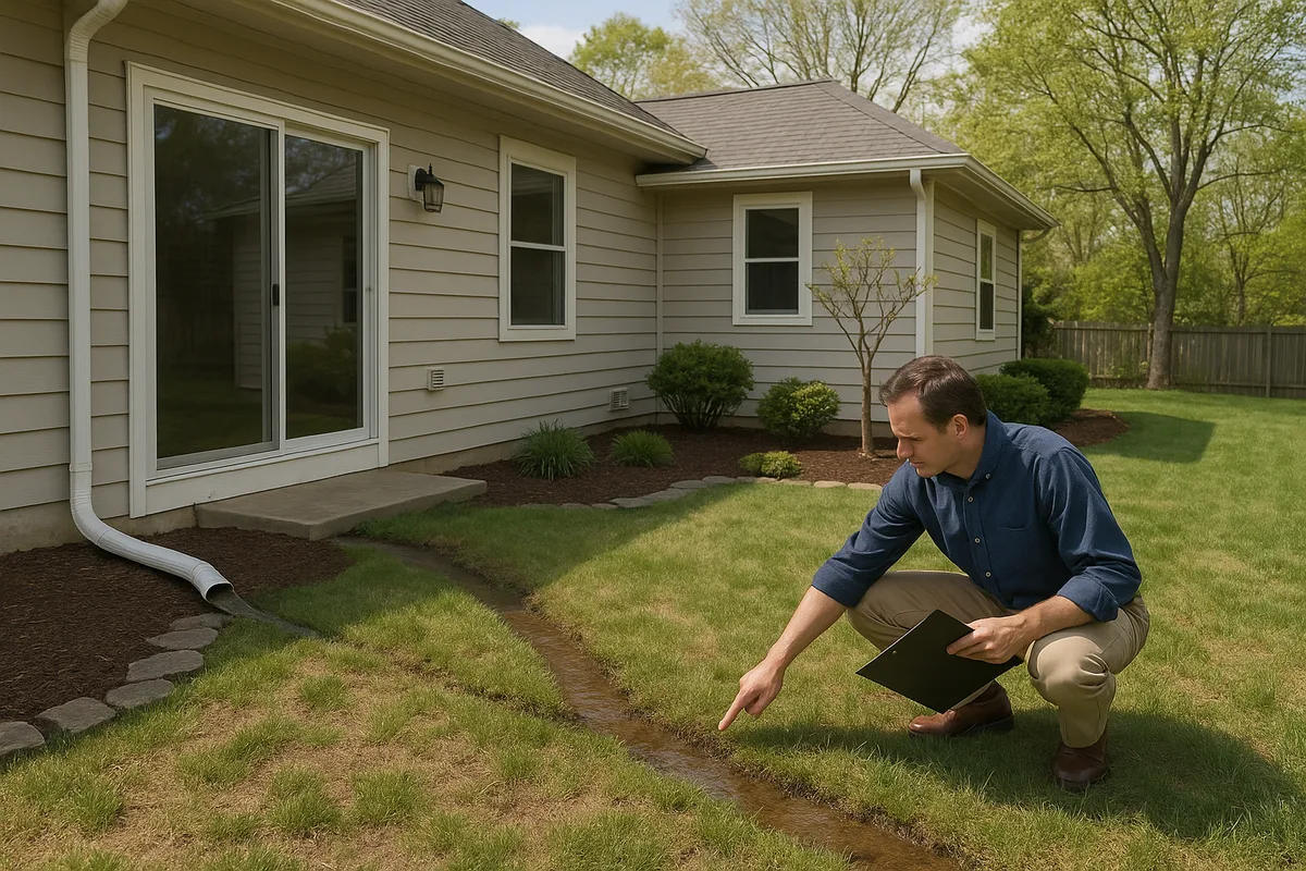
Regular monitoring of your property's drainage performance is essential. Walk your property during and after heavy rain events to observe where water flows, where it pools, and how quickly it drains. Compare current conditions to what you observed in previous years. If pooling is getting worse, if new wet spots are appearing, or if water is reaching areas it didn't previously affect, it's time for a fresh terrain analysis.
At Low Point Labs, we believe that understanding your property's terrain is the foundation of effective drainage management. Our topographic drainage intelligence services provide the detailed, property-specific insights you need to identify problems before they cause damage, design effective solutions, and monitor changes over time. Whether you're a homeowner dealing with a soggy backyard, a contractor planning a grading project, or an inspector evaluating drainage compliance, our terrain analysis tools give you the data-driven clarity you need. Explore our drainage assessment services today to discover what your terrain is telling you about where water will pool — and what you can do about it.
Get Your Drainage Intelligence Report™
Start a free trial and generate reports on demand.
Frequently Asked Questions
Related Articles
How to Analyze a Property's Natural Flow Paths: A Complete Guide
Why Some Homes Always Have Water Problems: The Root Causes