How Water Actually Flows Across Your Property: A Complete Guide
Every time it rains, a complex hydrological event unfolds across your property. Water doesn't simply fall and disappear — it moves, collects, accelerates, and infiltrates according to precise physical laws that most homeowners never think about until something goes wrong. Understanding how water actually flows on land is the single most important piece of knowledge you can have when it comes to protecting your home's foundation, preserving your landscaping, and preventing costly water damage.
At Low Point Labs, we've analyzed thousands of residential properties and discovered that the majority of drainage problems stem from a fundamental misunderstanding of surface water flow patterns. Homeowners often assume water will "find its way" off their property, but the reality is far more nuanced — and far more consequential. In this comprehensive guide, we'll walk you through exactly how water behaves when it hits your land, why it moves the way it does, and what you can do to work with — rather than against — the natural physics of drainage flow patterns.
The Basic Physics: Why Water Moves Where It Does
At its core, how water flows on land comes down to one simple principle: gravity pulls water downhill. But "downhill" on a residential property is rarely as straightforward as it sounds. Your yard isn't a uniform slope — it's a complex surface with subtle undulations, micro-depressions, varying soil types, and constructed features that all influence the path water takes. Even a difference of half an inch over ten feet can redirect hundreds of gallons of stormwater during a heavy rain event.
Water always seeks the path of least resistance to the lowest available point. Hydrologists call this concept "gravitational potential energy," and it governs every drop that lands on your property. When rain hits the ground, each droplet begins moving perpendicular to the contour lines of your terrain — that is, directly downslope along the steepest available gradient. These individual droplet paths converge into rivulets, rivulets merge into small channels, and channels combine into concentrated flow paths that can carry significant volumes of water with surprising erosive force.
The steepness of the slope — known as the gradient — determines how fast water moves. A slope of 2% (a quarter inch of drop per foot of horizontal distance) will move water at a moderate pace, giving it time to partially infiltrate the soil. A slope of 10% or greater will send water rushing across the surface so quickly that almost none of it soaks in, creating high-velocity runoff that can erode soil, undercut retaining walls, and overwhelm drainage infrastructure. The U.S. Geological Survey (USGS) provides excellent resources on how surface runoff contributes to the broader water cycle, and the same principles apply at the micro-scale of your backyard.
Sheet Flow vs. Concentrated Flow
When rain first begins falling on a relatively smooth surface — like your lawn or driveway — it spreads out in a thin, even layer called sheet flow. This is the gentlest form of surface water flow on a property, and it's actually what you want to see across most of your yard. Sheet flow distributes water's energy across a wide area, minimizing erosion and giving the soil maximum opportunity to absorb moisture.
However, sheet flow is inherently unstable. Within just 20 to 75 feet of travel (depending on surface roughness and slope), sheet flow begins to concentrate. Small imperfections in the terrain — a subtle depression, a line of compacted soil, the edge of a garden bed — cause water to converge into narrow streams. Once flow concentrates, its velocity and erosive power increase dramatically. A concentrated flow path carrying just two gallons per minute can carve a visible channel in bare soil within a single storm season. This transition from sheet flow to concentrated flow is one of the most important drainage flow patterns to understand on any residential property.
The Role of Friction and Surface Roughness
Not all surfaces allow water to flow at the same speed. Hydrologists use a value called Manning's roughness coefficient to describe how much a surface resists water flow. A smooth concrete driveway has a very low roughness coefficient (around 0.012), meaning water moves across it quickly with minimal resistance. A dense, healthy lawn has a much higher coefficient (0.15 to 0.25), meaning it significantly slows water down and encourages infiltration.
This is why the surfaces on your property matter enormously for drainage. Every square foot of impervious surface — concrete, asphalt, compacted clay, even synthetic turf with poor drainage backing — accelerates water and increases the total volume of runoff your drainage system must handle. A typical 2,000-square-foot roof generates approximately 1,250 gallons of runoff from just one inch of rainfall. Add a driveway, patio, and walkways, and a modest residential lot can easily produce 3,000 to 5,000 gallons of stormwater from a single moderate rain event.
Get Your Drainage Intelligence Report™
Start a free trial and generate reports on demand.
Reading Your Property's Topography
To understand how water flows across your specific property, you need to learn to read the land the way a hydrologist does. Every property has a topographic signature — a unique pattern of high points, low points, ridgelines, and valleys that dictates exactly where water will go. Most homeowners have never looked at their property this way, but once you do, drainage problems that seemed mysterious suddenly become obvious.
High Points, Low Points, and Ridgelines
Start by identifying the high points on your property. These are the areas where water diverges — flowing away in multiple directions. Your roof ridge is a high point. The crown of your driveway is a high point. That subtle rise between your yard and your neighbor's is a high point. Water will never collect at a high point; it will always flow away from one.
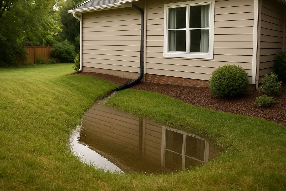
Next, find the low points — the areas where water converges and collects. These are the spots where you see puddles after a rain, where the grass stays green longest during dry spells, or where mud accumulates. Every property has at least one low point, and identifying it is critical. If your low point happens to be against your foundation wall, you have a serious problem that needs immediate attention.
Ridgelines (also called drainage divides) are the subtle elevated lines that separate one drainage area from another. Think of a ridgeline as an invisible wall that water cannot cross. On a residential property, ridgelines might follow the peak of a berm, the crown of a walkway, or even a subtle high line in the lawn that's invisible to the naked eye but clearly visible in topographic data. Understanding where your ridgelines fall tells you exactly which portions of your property drain toward your house and which drain away from it.
Drainage Basins on a Residential Scale
Hydrologists divide landscapes into drainage basins (or watersheds) — areas where all water flows to a single outlet point. Your property contains multiple micro-drainage basins, and identifying them is one of the most powerful things you can do for drainage management.
For example, your front yard might be one drainage basin that flows toward the street gutter. Your backyard might be another basin that flows toward a rear swale or storm drain. The area between your house and your neighbor's might form a third basin — one that could be directing water from both properties toward a shared low point. Each basin needs its own drainage strategy, and problems in one basin don't necessarily affect another.
At Low Point Labs, we use high-resolution topographic analysis to delineate these micro-basins on residential properties. The results often surprise homeowners. It's not uncommon to discover that a neighbor's regrading project has shifted a ridgeline, effectively redirecting hundreds of square feet of drainage area toward your foundation — a change that might be invisible to the eye but devastating to your basement.
How Your Home's Foundation Alters Natural Flow
Your house is the largest obstruction to natural water flow on your property. Before your home was built, water flowed across the land in patterns established over centuries of natural grading. Construction fundamentally disrupted those patterns, and the grading work done during construction was supposed to establish new, safe drainage flow patterns that direct water away from the foundation. Unfortunately, this grading doesn't always hold up over time.
The Critical "Positive Drainage" Requirement
Building codes across the United States require positive drainage away from foundations — meaning the ground must slope away from the house in all directions. The International Residential Code (IRC) specifies a minimum slope of 6 inches of fall within the first 10 feet from the foundation wall, which translates to a 5% grade. This standard exists because foundation walls are not designed to withstand sustained hydrostatic pressure from pooling water.
In practice, achieving and maintaining this 5% grade on all sides of a home is surprisingly difficult. Soil settles after construction — especially the backfill soil placed against foundation walls, which was loosened during excavation and never fully recompacts to its original density. It's common for this settlement to create negative drainage (slope toward the house) within just three to five years of construction. Flower beds built against the foundation, mulch accumulation, and even the decomposition of organic matter in the soil can all reduce the effective grade over time.
How Downspouts Create Concentrated Flow Problems
Your roof is an incredibly efficient water collection system. Every square foot of roof area captures every drop of rain that falls on it and channels it to your gutters and downspouts. The problem is that downspouts take the diffuse sheet flow from your entire roof and concentrate it into a handful of high-volume discharge points around your foundation's perimeter.
A single downspout serving 500 square feet of roof area will discharge approximately 312 gallons during one inch of rainfall. If that downspout terminates at a simple splash block right next to your foundation, all 312 gallons are being deposited within inches of the one structure you most need to keep dry. The surface water flow pattern created by an improperly managed downspout is one of the most common — and most preventable — causes of foundation water intrusion.
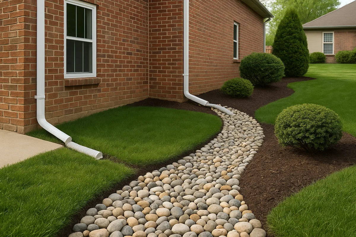
Best practice is to extend downspouts a minimum of 6 feet from the foundation, and ideally 10 feet or more. Underground downspout extensions connected to pop-up emitters or daylighting to a swale are even better, as they move the discharge point well away from the house and below the surface where it won't create erosion.
Subsurface Water Flow: What's Happening Underground
Surface water flow is only half the story. Beneath your lawn, a parallel drainage system operates according to its own set of rules. Understanding subsurface water movement is essential for a complete picture of how water behaves on your property.
Infiltration and Soil Permeability
When water hits the ground, some of it infiltrates into the soil. How much infiltrates — and how quickly — depends on the soil's permeability (also called hydraulic conductivity). Sandy soils are highly permeable, absorbing water at rates of 1 to 8 inches per hour. Clay soils are nearly impermeable, absorbing as little as 0.01 to 0.1 inches per hour. Most residential properties have soils somewhere in between, often with different soil types at different depths.
The infiltration rate matters enormously because it determines the split between water that soaks in and water that runs off. On a property with sandy loam soil, a moderate rainfall of 0.5 inches per hour might produce almost no surface runoff — nearly all the water infiltrates. On a property with heavy clay soil, that same rainfall could produce significant runoff because the soil simply can't absorb water fast enough.
Soil compaction dramatically reduces infiltration rates regardless of soil type. Construction equipment, foot traffic, and even riding mowers can compact the top several inches of soil to the point where it behaves like clay even if it's naturally sandy. This is why newly constructed homes often have worse drainage than the pre-construction grading plan predicted — the construction process itself damaged the soil's ability to absorb water.
Perched Water Tables and Subsurface Flow Paths
Once water infiltrates the soil, it doesn't just stop. It continues moving downward under gravity until it hits an impermeable layer — bedrock, a dense clay lens, or the water table itself. When water hits one of these barriers, it begins moving laterally, following the slope of the impermeable layer rather than the slope of the surface above.
This creates a phenomenon called a perched water table — a zone of saturated soil sitting on top of an impermeable layer, potentially well above the regional water table. Perched water tables are particularly insidious because they can direct water toward your foundation from unexpected directions. The surface of your yard might slope perfectly away from your house, but if there's a clay layer underground that tilts toward your foundation, subsurface water will flow toward your basement regardless of what the surface grading looks like.
This is one reason why surface-only drainage assessments can miss critical problems. At Low Point Labs, we consider both surface topography and subsurface conditions when analyzing drainage patterns, because the underground flow paths are often just as important as the visible ones.
Impervious Surfaces and the Multiplication Effect
One of the most significant ways human development changes how water flows on land is through the creation of impervious surfaces. Every roof, driveway, patio, sidewalk, and compacted area on your property prevents infiltration and converts rainfall directly into surface runoff. The cumulative effect can be dramatic.
Calculating Your Property's Impervious Coverage
A typical undeveloped lot might have an impervious coverage of less than 5% — just natural rock outcrops and compacted soil paths. A developed residential lot typically has 30% to 50% impervious coverage when you account for the house footprint, garage, driveway, walkways, and patio. Some heavily developed properties exceed 60%.
The Environmental Protection Agency (EPA) has documented that when impervious coverage exceeds 10% of a watershed, stream health begins to decline due to increased runoff volume and velocity. At the property scale, the effect is even more pronounced. A property with 40% impervious coverage will generate roughly five to seven times more stormwater runoff than the same property in its natural state. That's five to seven times more water that your drainage system must handle — water that arrives faster, with more energy, and with less opportunity to soak into the ground.
The Neighbor Effect: Off-Site Water Sources
Your property doesn't exist in isolation. Water flows across property lines with complete disregard for legal boundaries. Understanding how water flows onto your property from neighboring lots, streets, and uphill areas is just as important as understanding how it moves across your own land.
Common off-site water sources include:
- Uphill neighbor's runoff: If your property sits downhill from a neighbor, their surface runoff becomes your drainage problem. A neighbor who adds a patio, removes trees, or regrades their yard can significantly increase the volume of water flowing onto your property.
- Street runoff: If your property sits below street grade, road runoff can flow down your driveway and into your yard during heavy storms. This is especially common in older neighborhoods where streets were built up over decades of repaving.
- Subsurface flow from adjacent properties: Underground water doesn't respect property lines any more than surface water does. A neighbor's irrigation system or leaking pool can create subsurface flow that emerges as a wet spot in your yard.
- Redirected gutter discharge: A neighbor who extends their downspouts toward your shared property line is, in effect, redirecting their roof runoff onto your land.
Understanding these off-site contributions is essential for designing an effective drainage solution. You can perfect the grading on your own property, but if you're ignoring the 2,000 square feet of your neighbor's roof that drains toward your back fence, you're solving only part of the problem.
Seasonal and Storm-Intensity Variations in Flow Patterns
Drainage flow patterns on your property aren't static — they change with the seasons, with storm intensity, and even with the time of day. A drainage system that handles a gentle spring shower might be completely overwhelmed by a summer thunderstorm, and understanding these variations is critical for designing resilient drainage.
How Rainfall Intensity Changes Everything
The rate at which rain falls — measured in inches per hour — is often more important than the total amount of rain. A slow, steady rain of 0.25 inches per hour over four hours (1 inch total) gives soil time to absorb water and drainage systems time to convey it. The same 1 inch falling in 30 minutes (a rate of 2 inches per hour) will overwhelm most residential drainage systems and produce massive surface runoff.
Engineers design drainage systems to handle specific design storms — standardized rainfall events with defined intensities and durations. Most residential drainage is designed for the 10-year storm (a storm with a 10% chance of occurring in any given year). However, climate change is increasing rainfall intensity in many parts of the country. The storm that was a 10-year event in 1990 might now be a 5-year event, meaning your drainage system is effectively undersized for current conditions.
During high-intensity storms, flow patterns on your property can change dramatically. Areas that normally experience gentle sheet flow might develop concentrated channels. Low spots that normally drain between storms might fill up and overflow. Drainage infrastructure like French drains and channel drains can be overwhelmed, causing water to back up and find alternative paths — often toward your foundation.
Frozen Ground, Saturated Soil, and Antecedent Moisture
The condition of the soil when rain arrives — called antecedent moisture — dramatically affects how water flows. If the soil is already saturated from previous rainfall, it can't absorb any more water, and virtually all new rainfall becomes surface runoff. This is why the third day of a multi-day rain event often causes more drainage problems than the first day, even if the rainfall rate is the same.
Frozen ground behaves like an impervious surface. In cold climates, winter rain or snowmelt events can produce extreme runoff because the frozen soil prevents any infiltration whatsoever. A property that handles summer storms perfectly might experience significant flooding during a January thaw when frozen ground forces all snowmelt to run off across the surface.
Seasonal changes in vegetation also affect flow patterns. Deciduous trees that intercept and slow rainfall in summer provide no protection in winter. Lawns that are lush and absorbent in June might be dormant and compacted in February. These seasonal variations mean that your property's drainage performance in its worst-case scenario (saturated or frozen soil, dormant vegetation, high-intensity rainfall) may be dramatically different from its fair-weather performance.
Identifying Drainage Problems Through Flow Pattern Analysis
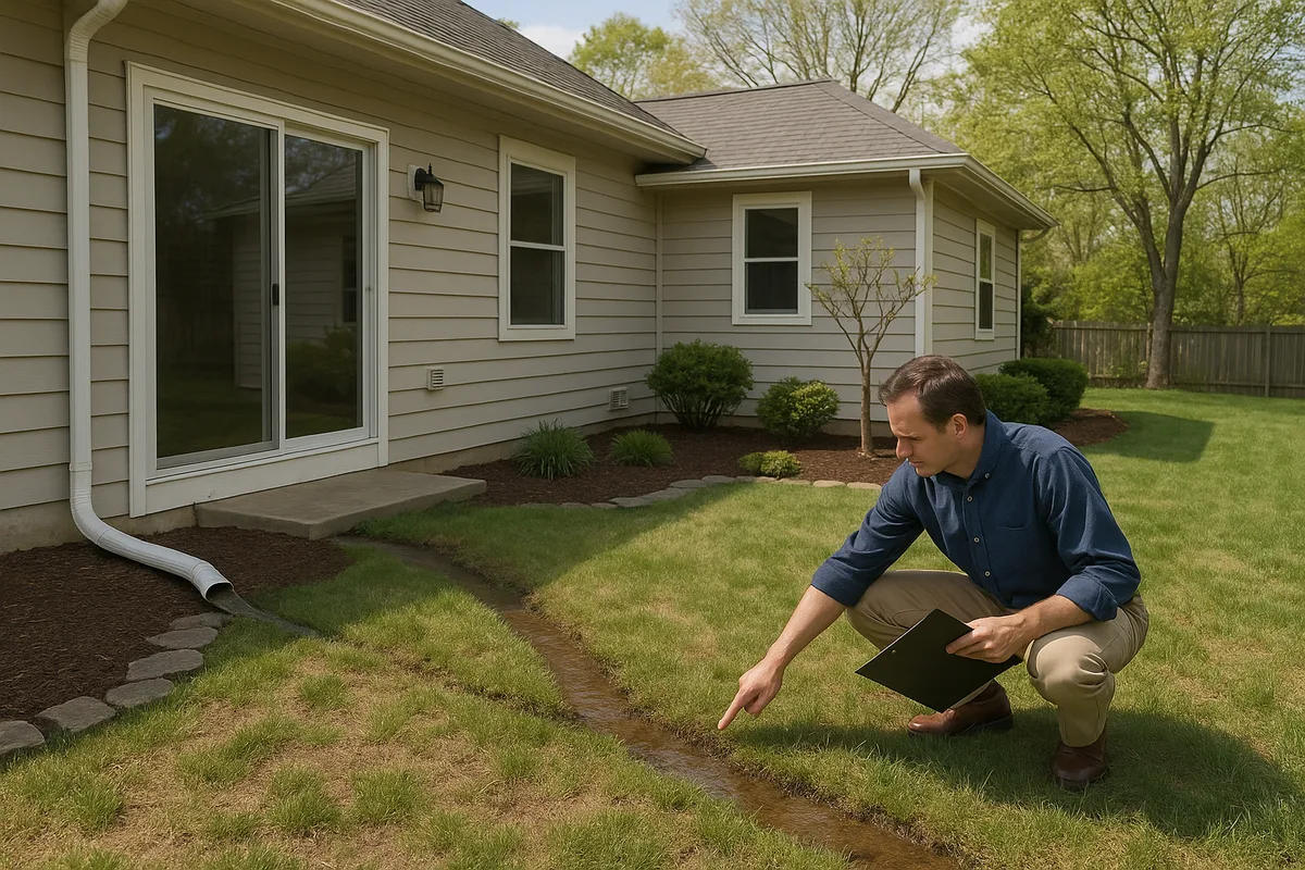
Now that you understand how water flows across your property, you can use that knowledge to identify existing or potential drainage problems. Many of these problems are visible if you know what to look for — and the best time to look is during or immediately after a heavy rain.
Visual Indicators of Problem Flow Patterns
Walk your property during a rainstorm (safely, of course) and observe where water is going. Look for these telltale signs of problematic surface water flow patterns:
Water flowing toward the foundation: Any visible flow moving toward your house indicates negative grading that needs correction. Pay special attention to areas near downspout discharge points and along the edges of patios or walkways that might be channeling water toward the house.
Standing water that persists more than 24 hours: After a moderate rain, all surface water should drain or infiltrate within 24 hours. Puddles that persist longer indicate a low point with no outlet — water is trapped with nowhere to go.
Erosion channels or rills: Visible channels carved into the soil indicate concentrated flow paths with excessive velocity. These channels will deepen over time and can undermine walkways, patios, and even foundation footings.
Mulch or soil displacement: If you notice mulch washing out of beds or soil migrating across walkways, water is moving through those areas with enough energy to transport material — a sign of excessive flow.
Staining on foundation walls: Horizontal stain lines on your foundation indicate past water levels. Vertical staining or efflorescence (white mineral deposits) suggests water is flowing down the foundation wall and potentially infiltrating.
Soggy or spongy areas in the lawn: Persistently wet areas indicate either a high water table, a subsurface flow path, or an area where surface water collects and slowly infiltrates. These areas are often the first to show stress during freeze-thaw cycles.
Using Simple Tools to Map Flow Direction
You don't need professional surveying equipment to get a basic understanding of your property's drainage patterns. A few simple tools and techniques can reveal a lot:
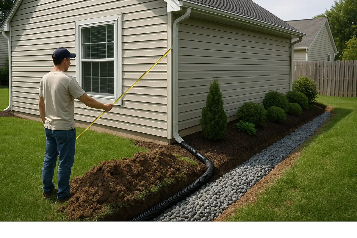
A long carpenter's level and a tape measure: Place the level on the ground with one end at your foundation wall. Raise the low end until the bubble centers, then measure the gap between the level and the ground. This tells you the slope direction and approximate gradient. Repeat at multiple points around your home.
A garden hose: On a dry day, place a running garden hose at various points around your property and watch where the water goes. This simulates rainfall and reveals flow paths that might not be obvious from the surface topography alone.
Flour or powdered chalk: Sprinkle a line of flour across a suspected flow path before a rain. After the storm, the flour will be washed away along the actual flow line, revealing the precise path water takes.
Photographs during rain: Take photos and videos during storms. These provide invaluable documentation of actual flow patterns and can be referenced later when planning drainage improvements.
While these DIY methods are useful for initial assessment, they can't replace the precision of professional topographic analysis. Subtle grade changes of less than an inch — invisible to the eye and undetectable with a carpenter's level — can redirect significant volumes of water. This is where high-resolution drainage intelligence, like the analysis Low Point Labs provides, becomes invaluable.
Working With Natural Flow: Principles for Better Drainage
The most effective — and most economical — drainage solutions work with your property's natural flow patterns rather than trying to fight them. Forcing water to flow in unnatural directions requires energy (pumps), infrastructure (pipes and drains), and ongoing maintenance. Guiding water along paths it naturally wants to follow requires only intelligent grading and strategic landscaping.
The Hierarchy of Drainage Solutions
When addressing drainage problems, work through solutions in this order, from simplest to most complex:
Correct the grading: Before installing any drainage infrastructure, ensure the surface grades are directing water away from structures and toward appropriate outlets. Regrading is often the single most effective and least expensive drainage improvement you can make. Aim for a minimum 2% slope (¼ inch per foot) across open lawn areas and maintain the code-required 5% slope (6 inches in 10 feet) adjacent to foundations.
Manage downspout discharge: Extend all downspouts to discharge at least 6 feet from the foundation, pointed downslope. Use underground extensions where surface extensions would be impractical or unsightly.
Intercept and redirect surface flow: Use shallow swales (graded depressions in the lawn) to intercept sheet flow before it reaches problem areas and redirect it to safe discharge points. A well-designed swale is barely visible but can handle enormous volumes of water.
Improve infiltration: Where appropriate, increase the soil's ability to absorb water through aeration, amendment with organic matter, or installation of rain gardens. This reduces total runoff volume and takes pressure off downstream drainage infrastructure.
Install drainage infrastructure: French drains, channel drains, catch basins, and piped systems should be the last resort, used only where grading and surface solutions can't fully solve the problem. These systems require ongoing maintenance and can fail if not properly designed and installed.
Designing for the Worst Case
Effective drainage design accounts for worst-case conditions, not average conditions. Your drainage system needs to function when the soil is saturated, the ground is frozen, the storm intensity exceeds normal levels, and multiple adverse factors combine. Designing for average conditions is designing for failure.
This means building in safety margins. If you need a 2% slope to handle normal rainfall, grade to 3% or 4% to provide a buffer. If your French drain needs to handle 10 gallons per minute during a design storm, size it for 15 or 20 gallons per minute. These margins cost very little during initial construction but provide enormous insurance against unusual conditions.
It also means thinking about what happens when your primary drainage system is overwhelmed. Where does the overflow go? If your swale can't handle the volume, does the excess water flow harmlessly across the lawn to the street, or does it back up against your foundation? Every drainage design should include an overflow path — a safe route for excess water when the primary system reaches capacity.
Taking Control of Your Property's Drainage
Understanding how water flows across your property transforms drainage from a mysterious, unpredictable problem into a manageable, solvable engineering challenge. The physics are straightforward: water flows downhill, follows the path of least resistance, and accelerates when concentrated. The complexity comes from the unique topography, soil conditions, and built features of your specific property.
The key takeaway is that surface water flow on your property follows predictable patterns that can be mapped, analyzed, and managed. Every puddle has a cause. Every wet basement has an explanation. Every erosion channel tells a story about where water is coming from and where it's trying to go. Learning to read these patterns is the first step toward solving drainage problems at their source rather than treating symptoms.
At Low Point Labs, we specialize in exactly this kind of topographic drainage intelligence. Our detailed property analyses reveal the flow paths, low points, drainage basins, and problem areas that are invisible to the naked eye but critical to effective drainage management. Whether you're dealing with a wet basement, a soggy yard, or you simply want to understand your property's drainage before problems develop, our assessments give you the data-driven insights you need to make smart decisions. Explore our drainage assessment services to see how your property's water actually flows — and what you can do about it.
Get Your Drainage Intelligence Report™
Start a free trial and generate reports on demand.
Frequently Asked Questions
Related Articles
How to Analyze a Property's Natural Flow Paths: A Complete Guide
Sizing a French Drain System by Contributing Drainage Area