Arrive Informed.
Inspect with Purpose.
Win the Work.
Drainage Intelligence for: Specialty Drainage Contractors · Foundation & Waterproofing Contractors · Landscapers & Grading Professionals
Pre-visit intelligence means fewer return trips, faster scopes, and less time spent on estimates that don't convert. More thorough scopes mean larger project values. Faster inspections mean more jobs per week. Higher close rates mean fewer wasted estimates. And a branded intelligence report in every client meeting means the kind of credibility that commands better margins, closes deals — and earns referrals.
Full access for 30 days. No contracts. Cancel anytime.
One Tool That Works Across the Whole Job
Drainage Intelligence Reports™ aren't a single-step utility. The same analysis follows the job from the first inspection through the design and into the conversation that wins the work.
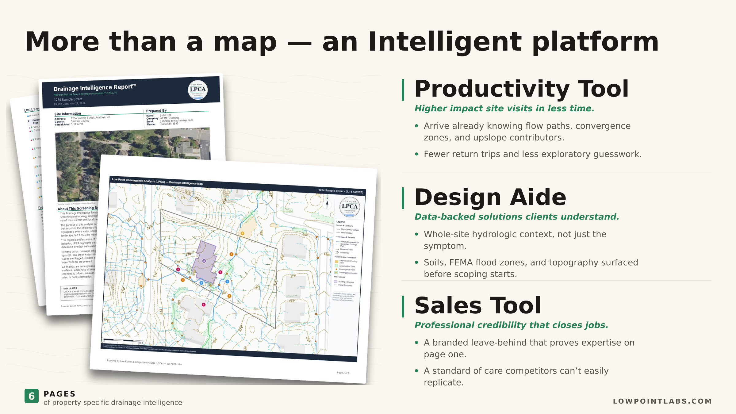
Inspection
You arrive with a strong read on where water is likely to collect and converge, so your time on-site goes to verifying those calls in the field — not hunting blind for where to start.
Design
Terrain-modeled flow paths and low-gradient ponding areas give you a head start on understanding the big picture faster — leading to tighter scopes, fewer surprises and defensible presentation.
Close
The homeowner sees the likely problem areas mapped, not just described — which turns "let me get other quotes" into a signature.
Stop Giving Away Free Estimates
Every free estimate is overhead — windshield time and expertise you hand out before a dollar comes in. Drainage intelligence changes that math: you prep from your desk, your site visits get more productive, and a sharper proposal closes at a higher rate. More hours on the jobs you've won, fewer on estimates that go nowhere. Plans start at $199/month.
An Investment That Pays
Better intel informs better proposals. Better proposals win more high-quality work. More high-quality work translates to better net margins. The subscription pays for itself many times over.
More Hours on Paying Work
Screen and prep before you drive out, so your hours go to jobs worth winning instead of estimates that never close.
Referrals That Compound
A homeowner impressed by your preparation sends the next job your way long after this one's done.
The subscription isn't a cost — it's what stops you from giving your expertise away for free.
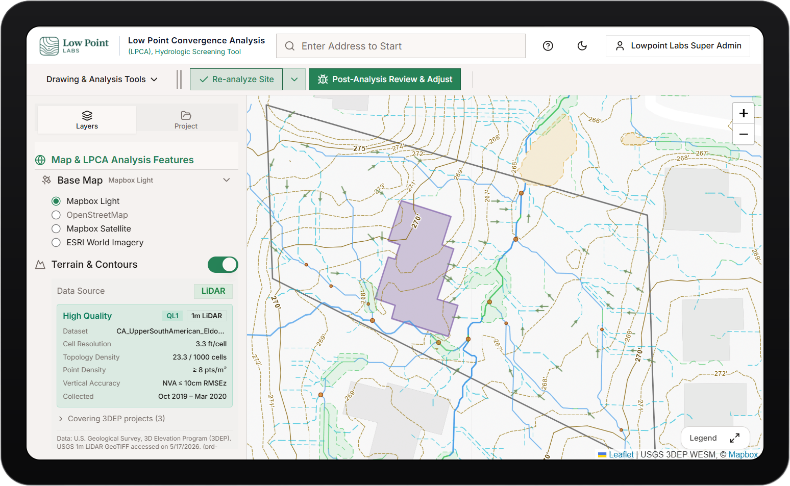
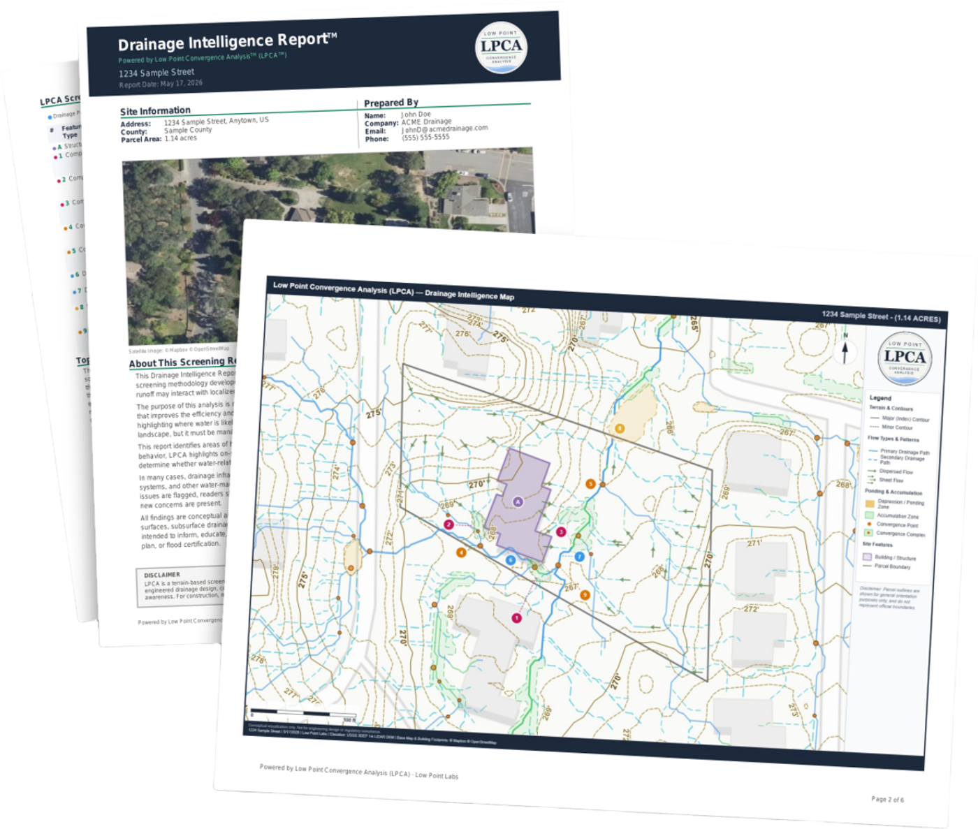
Terrain Data That Informs Your Work
Each Drainage Intelligence Report™ delivers professional, data-driven analysis — flow patterns plus the terrain, soil, and rainfall context behind them — to support your site assessment and bid preparation.
Flow Path Mapping
Visualizes how water moves across the property based on terrain elevation — showing primary flow routes and drainage direction to inform your grading plan.
Ponding Risk Zones
Identifies topographic depressions where water is likely to collect after rainfall, flagging areas that may need drainage solutions or regrading.
Convergence Analysis
Maps where multiple drainage flows meet, creating areas of concentrated runoff — critical data for sizing drainage infrastructure and planning outlet locations.
Contour Visualization
Professional contour maps showing subtle elevation changes that drive drainage patterns — the kind of terrain detail that's hard to read from a single walkthrough.
Structure Proximity
Assesses how drainage patterns relate to buildings on the property, highlighting areas where flow may direct water toward foundations or structures.
Contributing Factor Context
Interprets the factors behind the flow — terrain relief, regional soil types, and local climate information — to better inform why water behaves the way it does, enabling better diagnoses and solutions.
Give Clients a Reason to Choose You
Pre-visit hydrologic intelligence is new to the drainage market — a differentiator competitors can't easily replicate. Here's a simple way to explain your approach on the next bid.
"Other companies show up, walk the property, and give you their best guess. We take a more scientific approach. Before we ever set foot on your property, we study how water is likely to move across it — where it tends to collect and where the potential trouble spots are. So when we arrive, we already know where to focus, and we can design a system built around how water moves across your property."
It highlights your experience and instantly elevates your credibility — don't just sell the fix, sell the well-informed solution.
Built to Help You Win the Right Work
Terrain data doesn't replace your judgment — it backs it. Here's the edge it gives you when you're bidding against a walk-and-quote estimate.
Win More of What You Quote
A proposal backed by terrain maps and flow analysis reads as the credible one. You win more of the jobs you bid — without dropping your price to do it.
Solve It Once
Likely upslope contributors, convergence, and low points show up in the terrain analysis. Scope the whole site and you can address the underlying issue — not just the symptom that brings you back next season.
Look Like the Expert You Are
Hand over a branded Drainage Intelligence Report™ with your proposal and show the homeowner you did the homework before you arrived.
Put It to Work on Your Next Bid
Run reports on real jobs, include them in your proposals, and see what arriving informed does for your close rate. Start with a 30-day free trial — no contracts, cancel anytime.
Full access for 30 days. No contracts. Cancel anytime.
Questions from the Trades
Arrive Informed. Win the Work.
Bring Drainage Intelligence Reports™ into your business for better bids, sharper planning, and a more professional presentation. Start with a 30-day free trial — no contracts, no minimums.
Full access for 30 days. No contracts. Cancel anytime.