Understand Your Drainage
Before You Dig
Standing water, soggy yards, foundation concerns — stop guessing where the water goes. A Drainage Intelligence Report™ shows you exactly how terrain directs water across your property, so you can make smarter decisions before calling a contractor.
Using USGS LiDAR elevation data at ~1-meter resolution — no site visit required.
Subscribe to generate reports on demand. Cancel anytime.
You Can't Manage What You Can't See
Drainage patterns are shaped by subtle terrain features. Grade changes of just 2–3 inches can redirect hundreds of gallons of water toward your foundation, landscaping, or neighbor's property. Understanding these patterns is the first step toward informed property decisions.
Average cost of drainage repairs. Foundation issues from poor drainage can exceed $25,000 — often after years of invisible damage.
Of homeowners report water-related damage. Most never saw it coming because the terrain told a story they couldn't read.
Most drainage concerns aren't apparent from looking at the yard. LiDAR shows micro-topography that indicates where water is likely to travel.
"The terrain doesn't lie. Water always follows the path of least resistance — and that path is written into the topography of every property."
Common Scenarios Where the Report Pays for Itself
Whether you're dealing with an active issue or planning ahead, understanding your drainage is the smartest first step.
Standing Water or Soggy Yard
You've noticed puddles that won't drain, soggy spots after rain, or water pooling near the house. The report shows you exactly where water is converging and why.
Foundation Concerns
Water pooling near your foundation is the #1 cause of structural damage. See if terrain is directing water toward — or away from — your home.
Before Hiring a Contractor
Have your own independent terrain data before evaluating proposals. An independent drainage screening helps you compare bids, ask informed questions, and scope work accurately.
Planning Landscaping or Grading
Before you invest in landscaping, a patio, or regrading, understand how those changes might affect water flow across your property.
After Noticing Erosion
Erosion channels, washout areas, or exposed roots are signs of concentrated flow. The report maps where that flow may originate and how it may reach the affected area.
Before Building an Addition
An addition changes drainage patterns. Know the existing flow paths before breaking ground so your project works with the terrain, not against it.
Don't Wait for the Next Storm to Find Out
Enter your address to check coverage and get your Drainage Intelligence Report™.
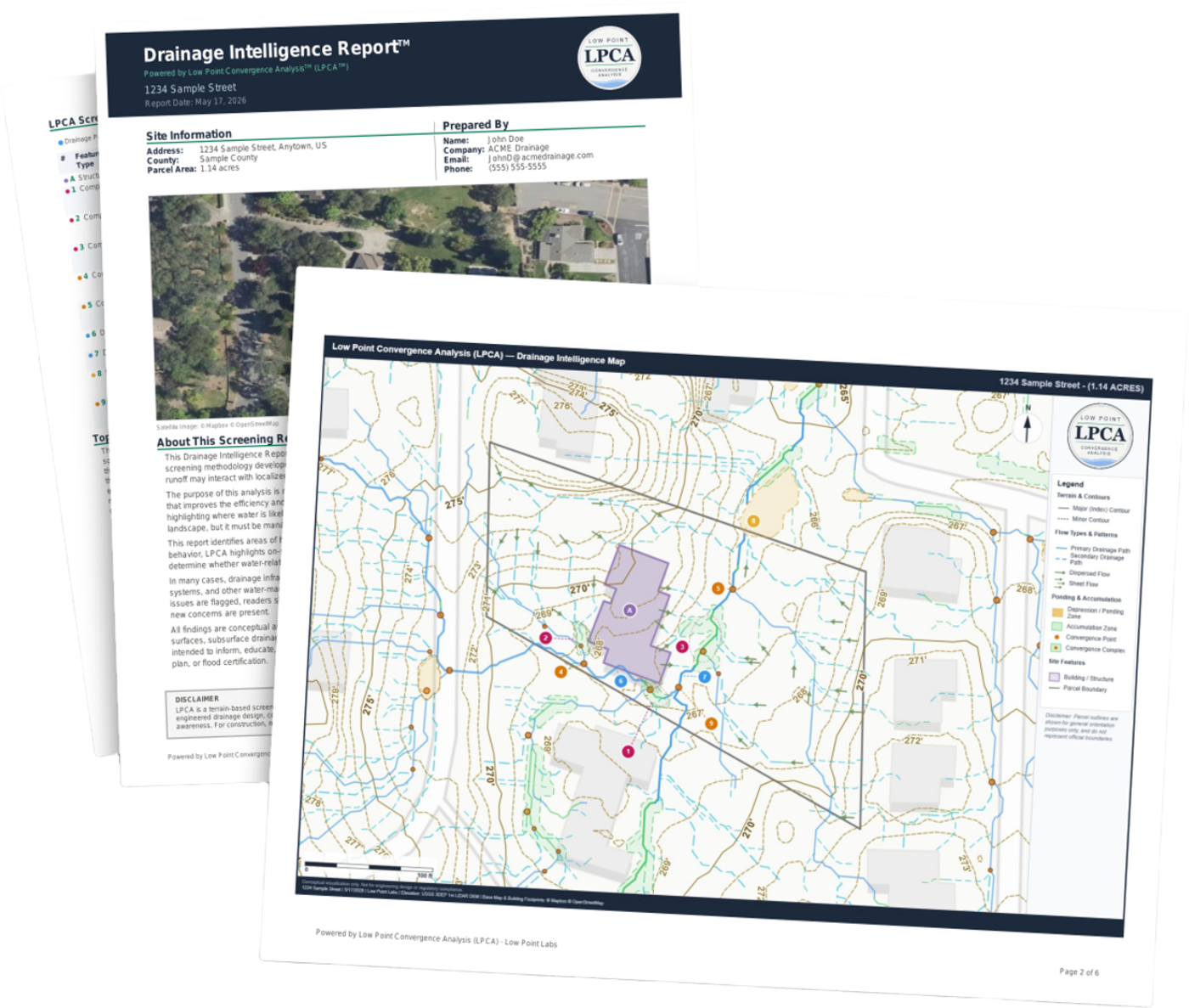
Your Report, Explained
Every Drainage Intelligence Report™ gives you a clear, property-specific picture of how water interacts with your terrain — and how your soil and local rainfall shape the way it drains.
Flow Path Analysis
See exactly where water travels across your property during rain events — including paths you'd never spot from the yard.
Ponding & Accumulation Zones
See where water is likely to collect and pool. Understand which low spots may contribute to standing water or foundation exposure.
Drainage Convergence Mapping
See where multiple flow paths merge into concentrated drainage — the areas most likely to experience erosion or saturated soil.
Contour & Grading Analysis
Understand the slope and grading patterns that shape how water moves. See where grade changes may be directing water toward structures.
Building Proximity Review
Analysis of how flow paths and accumulation zones relate to structures on your property — including your home's foundation.
Contributing Factor Context
Connects your terrain, soil type, and local rainfall to explain why water behaves the way it does on your property — in plain language, no engineering degree required.
Built on the Same Data Professionals Use
LiDAR resolution
Federal elevation data
Report delivery
100% remote analysis
Common Concerns, Straight Answers
"I'll just call a contractor to take a look."
A contractor evaluates what they can see on-site — and then recommends solutions they can sell. With this report, you walk into that conversation with an independent, data-driven picture of your entire property. You'll ask better questions, spot unnecessary upsells, and make more informed decisions.
"I can see my yard — it looks fine."
Drainage concerns are rarely visible from the surface. A grade change of just 2–3 inches can redirect hundreds of gallons of water. LiDAR data shows micro-topography that your eyes simply cannot see — subtle slopes and depressions that indicate where water is likely to travel during a storm.
"This seems expensive for a report."
The average drainage repair costs $5,000–$15,000. A single contractor visit for a consultation can be $200–$500. This report costs a fraction of either, covers your entire property, and gives you the terrain data to make informed decisions about where to focus your attention and budget.
"What if it flags something that's already been fixed?"
That's expected — and by design. The report identifies where terrain suggests potential drainage activity based on topography. If you've already installed French drains, regraded, or added swales, the report confirms those were the right locations. The value is validation as much as discovery.
Important: This Is a Screening Tool
This report identifies where terrain may direct water — not where problems definitively exist. Many flagged areas may already have drainage solutions in place. This report helps you understand what's happening below the surface level and what questions to ask professionals. It does not replace engineering assessments, soil analysis, or on-site evaluations.
Frequently Asked Questions
Know Your Property's Drainage Story
Every property tells a story through its terrain. Enter your address to check coverage and start your subscription — generate Drainage Intelligence Reports™ on demand.
Subscribe to generate reports on demand. Cancel anytime.