A State Where Two Climates Collide Underground
Washington is the only state in the lower 48 where you can find a property sitting on ancient volcanic ash that absorbs water like a sponge just 150 miles from another property sitting on glacial till so dense it might as well be concrete. The Cascade Range doesn't just split the state into a wet side and a dry side — it creates two entirely different drainage universes, each with its own soil chemistry, precipitation regime, and failure modes. On the west side, Seattle averages 37 inches of rain per year, but that number disguises the real problem: nearly 80% of it falls between October and April, creating six months of relentless saturation followed by a dry summer that lulls property owners into forgetting what's coming. On the east side, Spokane gets roughly 17 inches, but its volcanic ash soils and freeze-thaw cycles create drainage failures that look nothing like anything you'd see in Tacoma or Olympia.
What makes Washington's drainage landscape especially treacherous for property owners is the state's geology. The last glacial retreat, roughly 12,000 to 15,000 years ago, left behind a layered geological sandwich across much of the Puget Sound lowland: permeable outwash gravels sitting atop impermeable glacial till, often with perched water tables trapped between them. Developers in the mid-20th century built thousands of homes on these formations without fully understanding them. Today, those homes experience basement seepage, foundation heave, slope instability, and yard flooding that seems to defy logic — water appearing where it "shouldn't" be, because the subsurface geology is directing it in ways that surface grading alone can't explain.
This guide is built for Washington property owners, buyers, inspectors, and contractors who need to understand what's actually happening beneath their properties — and what to do about it.
Washington's Drainage Geology: What's Under Your Property
The Puget Sound Lowland: Glacial Till and Outwash
The Puget Sound lowland — stretching from Bellingham south through Seattle, Tacoma, and Olympia — is defined by glacial deposits left by the Vashon ice sheet. Understanding these deposits is the single most important factor in diagnosing drainage problems on the west side of the state.
The typical stratigraphic sequence in the Puget lowland looks like this from bottom to top:
- Pre-Vashon deposits: Older glacial and interglacial sediments, often compacted and relatively impermeable
- Vashon till: A dense, unsorted mix of clay, silt, sand, and gravel compressed under thousands of feet of ice. This layer is the primary villain in western Washington drainage problems. It has extremely low permeability — water moves through it at rates measured in fractions of an inch per hour
- Vashon outwash: Coarse sand and gravel deposited by glacial meltwater. This layer drains well — sometimes too well, creating underground channels that concentrate flow
- Recessional outwash and lacustrine deposits: Fine-grained silts and clays deposited in glacial lakes as the ice retreated
The critical problem is that Vashon till often sits just a few feet below the surface, creating what hydrologists call a "perched water table." Rainwater infiltrates through the topsoil and any outwash material, hits the till, and then moves laterally along the till surface. This is why so many homes in neighborhoods like Burien, Federal Way, Renton, and parts of North Seattle experience water intrusion on hillsides — the water isn't coming from above, it's migrating horizontally through the subsurface and emerging at the foundation.
You can investigate your property's soil profile through the USDA Web Soil Survey, which provides detailed maps of soil series, drainage class, and depth to restrictive layers for every parcel in Washington. In the Puget lowland, look for soil series names like Alderwood (the most common — a gravelly sandy loam over dense till), Everett (well-drained outwash), and Bellingham (poorly drained lowland soils). Each tells a different drainage story.
The Cascade Foothills: Volcanic Influence and Steep Slopes
As you move east from the Puget lowland into the Cascade foothills — communities like Issaquah, North Bend, Enumclaw, and Eatonville — the geology shifts. Volcanic deposits from Mount Rainier, Mount Baker, and other Cascade volcanoes mix with glacial sediments. Lahars (volcanic mudflows) from Mount Rainier created the broad, flat valleys of the Puyallup and White River systems. Homes built on lahar deposits sit on material that can be surprisingly well-drained near the surface but unpredictable at depth.
Slope is the dominant drainage variable in the foothills. Washington's steep terrain means that even modest rainfall generates significant surface runoff velocity. The USGS maintains streamflow gauges throughout the Cascade foothills that document how quickly small creeks can surge during atmospheric river events — a 2-inch rainfall over 24 hours can produce bankfull conditions in tributaries that were barely flowing the day before.
Eastern Washington: Loess, Volcanic Ash, and the Channeled Scablands
Eastern Washington's drainage challenges are fundamentally different. The dominant soil parent material is loess — wind-deposited silt blown from glacial flood deposits during the Pleistocene. Loess soils are deep, fertile, and highly erodible. In the Palouse region around Pullman and Colfax, loess deposits can be 200 feet deep.
In and around Spokane, the soil profile includes significant volcanic ash from Cascade eruptions, particularly the Mount Mazama eruption (which created Crater Lake) roughly 7,700 years ago. This ash layer creates a distinct drainage signature: it's lightweight, porous, and initially absorbs water readily, but once saturated, it can become a slippery, unstable layer that contributes to slope failures.
The Channeled Scablands — the dramatic landscape carved by the Missoula Floods — underlie portions of the Columbia Basin. Properties in communities like Moses Lake, Ephrata, and portions of the Tri-Cities sit on basalt bedrock with thin soil cover. Drainage here is controlled almost entirely by the fractured basalt — water either infiltrates through cracks in the basalt or runs off the surface with almost nothing in between.
The NRCS classifies eastern Washington soils into hydrologic soil groups that directly predict drainage behavior. Much of the Palouse falls into Group B (moderate infiltration), while areas with shallow basalt fall into Group D (very slow infiltration, high runoff potential).
Climate Patterns and Their Drainage Implications
Western Washington: The Atmospheric River Problem
Western Washington's drainage challenges are driven not by total annual rainfall — 37 inches is moderate by national standards — but by the intensity, duration, and seasonality of precipitation events. The region is increasingly affected by atmospheric rivers, narrow corridors of moisture that can deliver 3-6 inches of rain over 48-72 hours.
The National Weather Service categorizes atmospheric rivers on a scale from 1 (beneficial) to 5 (hazardous). Western Washington typically experiences several Category 2-3 events per season, with occasional Category 4-5 events that overwhelm drainage infrastructure. The November 2021 atmospheric river that devastated Sumas, Everson, and portions of the Skagit Valley demonstrated how quickly these events can exceed engineered capacity.
For residential drainage, the key metric isn't average rainfall — it's the design storm. Washington's Department of Ecology requires stormwater systems to be designed for specific return-period storms, and NOAA provides the precipitation frequency data that defines these storms. In the Puget Sound region, the 25-year, 24-hour storm delivers approximately 3.5-4.5 inches depending on location. Your drainage system needs to handle this volume without causing damage to your property or your neighbors'.
The seasonal pattern matters enormously for foundation health. Six months of near-continuous moisture from October through March saturates soils and raises water tables. Then three to four months of relative drought from June through September dries out clay-rich soils, causing them to shrink and crack. This wet-dry cycle is a primary driver of foundation settlement in western Washington — not dramatic flooding, but the slow, seasonal expansion and contraction of moisture-sensitive soils.
Eastern Washington: Freeze-Thaw and Rapid Snowmelt
Eastern Washington's drainage problems are often seasonal and sudden. The region experiences true winters with sustained freezing temperatures, and the spring thaw can release large volumes of water in a short period. When frozen ground prevents infiltration and warm Chinook winds accelerate snowmelt, surface runoff can be extreme.
Spokane's drainage infrastructure must handle a unique dual challenge: winter ice that blocks storm drains and spring melt that overwhelms them. The city's aquifer — the Spokane-Rathdrum Prairie Aquifer, one of the most productive sole-source aquifers in the nation — adds another dimension. Because the aquifer is highly permeable and lies close to the surface in many areas, drainage decisions on individual properties can affect groundwater quality for the entire region.
The Tri-Cities (Richland, Kennewick, Pasco) receive only 6-8 inches of annual precipitation but face drainage challenges from irrigation return flows, rapid development on previously agricultural land, and occasional intense thunderstorms that drop significant rainfall on soils with limited infiltration capacity.
Washington's Stormwater Regulatory Framework
Washington has one of the most comprehensive stormwater regulatory frameworks in the nation, and it directly affects what residential property owners can and cannot do with water on their properties.
The Department of Ecology Stormwater Manuals
The Washington State Department of Ecology publishes stormwater management manuals that serve as the regulatory backbone for the entire state. There are separate manuals for western Washington and eastern Washington, reflecting the dramatically different conditions on each side of the Cascades. These manuals establish minimum requirements for stormwater management that local jurisdictions must meet or exceed.
For residential property owners, the most relevant requirements include:
- Minimum Requirement #1: Preparation of a stormwater site plan for any project that creates or replaces impervious surface
- Minimum Requirement #5: On-site stormwater management — this is where low-impact development (LID) techniques like rain gardens and permeable pavement come in. Washington has been a national leader in requiring LID as the preferred approach
- Minimum Requirement #7: Flow control — new development must match pre-development runoff rates for a range of storm events
The EPA has recognized Washington's stormwater program as one of the most progressive in the country, particularly its integration of low-impact development principles into regulatory requirements rather than treating them as optional best practices.
NPDES Municipal Stormwater Permits
Most urban and suburban areas in Washington operate under National Pollutant Discharge Elimination System (NPDES) municipal stormwater permits. These permits, issued by the Department of Ecology under authority delegated from the EPA, require cities and counties to regulate stormwater discharges from private properties.
What this means practically for homeowners:
- You cannot discharge concentrated stormwater onto a neighbor's property without their consent and potentially without a permit
- Clearing and grading permits are required in most jurisdictions for any land disturbance over a threshold area (typically 2,000-7,000 square feet depending on jurisdiction)
- Connection to the public storm drain system may require a permit and must meet water quality standards
- Illicit discharge prohibitions mean you cannot route pool water, wash water, or other non-stormwater flows into the storm drain system
Critical Areas Ordinances
Washington's Growth Management Act requires all cities and counties to adopt Critical Areas Ordinances (CAOs) that protect wetlands, fish and wildlife habitat, frequently flooded areas, geologically hazardous areas, and critical aquifer recharge areas. These ordinances impose buffers and development restrictions that directly affect drainage on residential properties.
If your property is near a stream, wetland, or steep slope, your drainage options may be significantly constrained by your local CAO. Work within a stream buffer without a permit and you could face fines of $1,000 per day or more, plus restoration costs that routinely exceed $50,000. The Army Corps of Engineers also has jurisdiction over wetlands and waters of the United States, adding a federal layer to the permitting process.
Real Estate Disclosure Requirements
Washington's Seller Disclosure Statement (Form 17) requires sellers to disclose known material facts about the property, including:
- Known drainage problems
- Standing water or flooding
- Whether the property is in a flood zone or floodplain
- Known soil stability problems
- Whether the property has been subject to landslides or earth movement
Failure to disclose known drainage problems can result in significant legal liability. Washington courts have consistently held that sellers who knew about water intrusion, flooding, or drainage deficiencies and failed to disclose them can be liable for repair costs, diminished value, and in some cases, rescission of the sale. The HUD guidelines on property condition disclosure provide additional context for federally-backed mortgage transactions.
Diagnosing Drainage Problems on Your Washington Property
Identifying drainage issues before they cause structural damage is the most cost-effective thing a Washington property owner can do. Here's a systematic approach tailored to Washington conditions.
The Rainy Season Walk-Through
The best time to assess drainage is during active rainfall — ideally during a sustained rain event in November through February. Put on rain gear and walk your property during and immediately after a moderate to heavy rain. You're looking for:
- Surface ponding: Any area where water collects and stands for more than 30 minutes after rain stops. In western Washington, some ponding is normal in low areas with till subsoils, but ponding within 10 feet of a foundation is a red flag
- Concentrated flow paths: Erosion channels, rills, or areas where water is flowing in a defined channel across your yard. These indicate that runoff volume or velocity exceeds what the soil and vegetation can absorb
- Foundation seepage: Check your crawl space or basement during rain. In the Puget Sound region, standing water in crawl spaces is alarmingly common — and alarmingly often ignored. Look for water stains on foundation walls, efflorescence (white mineral deposits), and active water entry
- Saturated soils: Walk across your yard. If your feet sink more than half an inch, the soil is saturated and the water table may be near the surface. In areas with Alderwood soils (western Washington's most common residential soil), this is typical during winter
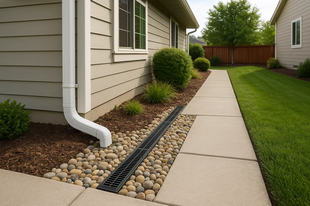
- Downspout discharge: Follow every downspout to see where the water goes. In many Washington homes built before 2000, downspouts are connected to the footing drain system — a practice that overloads the drain and is now prohibited by code in most jurisdictions
The Dry Season Assessment
Summer in Washington provides different diagnostic opportunities:
- Soil cracking: In areas with clay-rich soils (common in the Tacoma, Olympia, and Vancouver areas), look for desiccation cracks in the soil near your foundation. Cracks wider than 1/4 inch indicate expansive soil behavior that can cause foundation movement
- Vegetation patterns: Areas with persistently green grass during dry periods may indicate a high water table or subsurface seepage. Conversely, dead patches may indicate areas where water concentrates during wet months and drowns roots
- Grading assessment: With dry, firm ground, you can more accurately assess surface grades. Use a 4-foot level and tape measure to check that the ground slopes away from your foundation at a minimum of 2% (about 1/4 inch per foot) for at least 6 feet. In Washington, I recommend 5% (5/8 inch per foot) because of the sustained wet season
- Retaining wall condition: Western Washington is full of retaining walls, many of them failing. Look for tilting, bulging, cracking, or separation at joints. Failed retaining walls are a drainage problem as much as a structural one — they often fail because the drainage behind them has clogged or was never installed
Subsurface Investigation
For properties with persistent or unexplained drainage problems, surface observation isn't enough. Washington's layered glacial geology means the answer is often underground.
- Hand auger test: Rent or buy a hand auger and bore several test holes around your property to a depth of 3-4 feet. Note where you hit water, where you encounter different soil layers, and particularly where you hit dense, gray, impermeable till. This simple test reveals more about your drainage than almost anything else you can do
- Percolation testing: Dig a hole 12 inches in diameter and 12 inches deep, fill it with water, let it drain completely, then fill it again and time how long it takes to drop 1 inch. In Puget Sound lowland soils over till, rates of 0.5 inches per hour or less are common — far too slow for effective on-site infiltration
- Review your soil survey: The USDA Web Soil Survey will tell you your soil series, drainage class, depth to restrictive layer, and hydrologic soil group. This is free, publicly available information that every Washington property owner should review
Common Drainage Solutions for Washington Properties
Surface Grading and Regrading
Proper surface grading is the foundation of every drainage solution — pun intended. In Washington, grading is both critically important and frequently inadequate.
The minimum standard is 6 inches of fall in the first 10 feet away from the foundation, but for western Washington's sustained wet season, more is better. Many homes in the Puget Sound region were built on lots that have since settled, particularly in areas with organic soils or fill. What was adequate grading at construction may now direct water toward the foundation.
Regrading costs in Washington typically range from $1,500 to $5,000 for a typical residential lot, depending on the extent of work, access, and whether retaining walls or landscape features are affected. In the Seattle metro area, expect the higher end of this range due to labor costs and the frequent need for structural fill to replace organic or poorly-draining native soil.
Washington-specific consideration: Many properties in the Puget Sound region have mature trees — particularly Douglas firs and western red cedars — whose root systems constrain grading options. Significant grading within the drip line of these trees can damage roots and potentially violate local tree protection ordinances. Work with an arborist if large trees are near the areas requiring regrading.
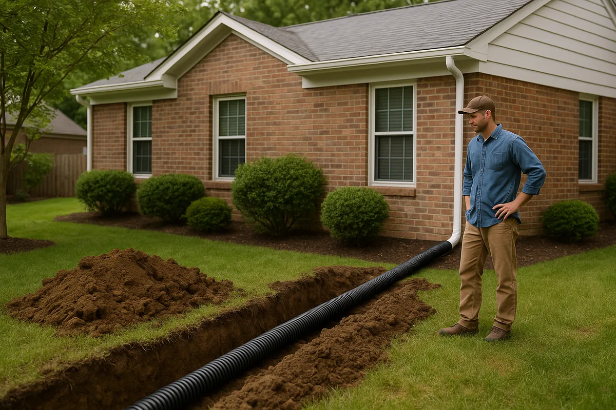
French Drains and Curtain Drains
French drains (also called curtain drains when installed to intercept subsurface flow on a hillside) are the workhorse drainage solution for western Washington properties. They consist of a perforated pipe in a gravel-filled trench, designed to intercept and redirect subsurface water.
In Washington's glacial till environment, French drains serve a specific and critical function: they intercept the lateral flow of water along the till surface before it reaches the foundation. A properly designed curtain drain is installed upslope of the home, keyed into the till layer, and routed to a discharge point downslope or to the storm drain system.
Key specifications for Washington installations:
- Pipe: 4-inch perforated HDPE or PVC, with perforations facing down (this is counterintuitive but correct — the pipe collects water that rises into it from below)
- Aggregate: 3/4-inch to 1-1/2-inch washed, crushed rock. Do NOT use round river rock — it migrates and settles. The NDS drainage products catalog provides specifications for aggregate and pipe compatible with Washington soil conditions
- Filter fabric: Non-woven geotextile wrapped around the aggregate (not the pipe). In Washington's silty soils, filter fabric is essential to prevent migration of fines into the gravel and eventual clogging
- Depth: Must reach the till layer or the depth of the water intrusion, whichever is deeper. In the Puget Sound lowland, this is typically 2-4 feet
- Slope: Minimum 1% grade (1/8 inch per foot) to the discharge point. More is better — aim for 2% if topography allows
Costs for French drain installation in Washington range from $25 to $60 per linear foot, depending on depth, access, and soil conditions. A typical residential installation of 80-150 linear feet runs $3,000 to $9,000. In areas with rocky glacial outwash (common in parts of Snohomish and Skagit counties), excavation costs increase significantly.
Footing Drains and Foundation Waterproofing
Washington building code requires footing drains on all new construction with habitable space below grade. However, many older homes — particularly those built before 1980 — either lack footing drains entirely or have drains that have clogged, collapsed, or been overwhelmed by downspout connections.
If your home has chronic basement or crawl space water intrusion that surface grading and French drains don't resolve, the footing drain system likely needs rehabilitation or replacement. This is major work — it requires excavating around the foundation perimeter — but it's the definitive solution for below-grade water intrusion.
A complete footing drain rehabilitation in western Washington typically costs $8,000 to $25,000 depending on home size, access, depth, and whether waterproofing membrane is applied to the foundation wall. In the Seattle metro area, the upper end of this range is common.
Critical Washington detail: If your home's footing drains are connected to the sanitary sewer system (common in older Seattle, Tacoma, and Everett neighborhoods), you may be required to disconnect them as part of ongoing inflow and infiltration (I&I) reduction programs. This means finding an alternative discharge point — typically the storm drain system or a dispersal trench — which adds complexity and cost.
Rain Gardens and Bioretention
Washington has been at the forefront of rain garden adoption, and for good reason — they're well-suited to the state's climate and regulatory environment. A rain garden is a shallow, planted depression designed to capture and infiltrate stormwater runoff from impervious surfaces like roofs and driveways.
The Department of Ecology's stormwater manual includes detailed specifications for bioretention facilities, and many Washington jurisdictions offer incentives — including reduced stormwater utility fees — for properties that install them.
Rain garden design in Washington must account for local soil conditions:
- Over well-drained outwash soils (common in parts of Thurston, Lewis, and Pierce counties): Rain gardens can infiltrate directly into native soil. Size the garden to capture the first 3/4 inch of rainfall from the contributing impervious area
- Over glacial till (most of the Puget Sound lowland): Rain gardens need an underdrain — a perforated pipe at the bottom that routes water that doesn't infiltrate to an approved discharge point. Without an underdrain, a rain garden over till becomes a mosquito-breeding pond
- Over loess soils in eastern Washington: Rain gardens work well during the growing season but may not function during winter when soils are frozen. Design for seasonal operation
The American Society of Landscape Architects provides design resources for bioretention facilities that complement Washington's regulatory requirements. Professional rain garden installation costs $3,000 to $8,000 in Washington, though DIY installations using native plants can be done for $500 to $1,500 in materials.
Sump Pumps and Crawl Space Management
In western Washington, sump pumps are a reality of life for thousands of homeowners. If your home has a crawl space — and the majority of Washington homes built before 1990 do — managing moisture in that space is essential for both structural health and indoor air quality.
A properly managed crawl space in western Washington includes:
- Vapor barrier: 6-mil or thicker polyethylene sheeting covering the entire crawl space floor, sealed at seams and edges. This is code-required for new construction and should be retrofitted in older homes
- Sump pit and pump: If standing water occurs in the crawl space during wet months, a sump system is necessary. Install the pit at the lowest point of the crawl space, with a reliable pump (battery backup is strongly recommended given western Washington's frequent power outages during storms)
- Ventilation: Washington code requires crawl space ventilation, though conditioned (sealed and insulated) crawl spaces are increasingly common and often perform better in terms of moisture management
- Discharge: Sump pump discharge must be routed away from the foundation — at least 10 feet, and ideally to a dispersal area, dry well, or storm drain connection. Discharging sump water onto a neighbor's property is a violation of Washington's stormwater regulations and a frequent source of neighbor disputes
Dry Wells and Infiltration Systems
In areas with permeable soils (outwash gravels, sandy loams), dry wells provide an effective way to manage concentrated roof runoff. A dry well is essentially a buried chamber filled with gravel or containing a manufactured infiltration unit that stores water temporarily and allows it to percolate into the ground.
Dry wells work well in parts of Thurston County, the Kitsap Peninsula, portions of Snohomish County, and areas of eastern Washington with deep, permeable soils. They do NOT work in areas with shallow glacial till, high water tables, or clay soils — attempting to install a dry well in Alderwood soil over till is a waste of money.
Before installing a dry well, conduct a percolation test at the proposed depth. If the rate is less than 1 inch per hour, a dry well is not appropriate for your site.
Retaining Wall Drainage
Western Washington's hilly terrain means retaining walls are ubiquitous — and retaining wall drainage failures are one of the most common and expensive problems property owners face. A retaining wall without adequate drainage is a dam, and hydrostatic pressure will eventually cause it to fail.
Every retaining wall in Washington should have:
- Drain rock backfill: 12-18 inches of free-draining aggregate behind the wall face
- Perforated drain pipe: At the base of the wall, sloped to daylight or a discharge point
- Filter fabric: Between the drain rock and native soil to prevent migration of fines
- Weep holes: In concrete and masonry walls, at regular intervals along the base
Retaining wall failures in Washington commonly cost $15,000 to $75,000 to repair, depending on wall height, length, and site access. Many of these failures could have been prevented with $2,000 to $5,000 in drainage provisions during original construction.
Regional Drainage Profiles
Seattle Metro Area
Seattle's drainage challenges are defined by its topography — a series of steep hills and narrow valleys — combined with dense urban development and aging infrastructure. The city's combined sewer system in older neighborhoods (parts of Capitol Hill, Beacon Hill, Rainier Valley, and West Seattle) means that heavy rain events can overwhelm the system, causing combined sewer overflows into Puget Sound and Elliott Bay.
King County's stormwater utility charges property owners based on impervious surface area, creating a financial incentive to manage stormwater on-site. Seattle's RainWise program has historically offered rebates for rain gardens and cisterns in targeted basins — check current eligibility if you're in the city.
Specific Seattle neighborhoods with notable drainage challenges include:
- Broadview and Bitter Lake: Glacial deposits over till with a shallow water table. Chronic crawl space flooding
- Beacon Hill and Georgetown: Historically industrial fill soils with unpredictable drainage characteristics
- West Seattle: Steep slopes over till creating landslide hazards. The city's landslide-prone areas map identifies parcels with elevated risk
- Rainier Valley: Former wetlands and floodplain of the Duwamish River, with high water tables and organic soils
Tacoma and Pierce County
Tacoma sits on a bluff above Commencement Bay, and the transition from bluff top to tideland creates dramatic drainage gradients. Properties along the bluff edges in neighborhoods like Stadium District, Old Town, and parts of North Tacoma face slope stability challenges exacerbated by drainage. Pierce County's stormwater management program is one of the most active in the state, with strict requirements for new development and redevelopment.
The Puyallup River valley — including communities like Puyallup, Sumner, and Orting — sits on lahar deposits from Mount Rainier. These soils are generally well-drained but the valley floor is a flood-prone area. FEMA flood maps show extensive Special Flood Hazard Areas along the Puyallup and its tributaries, and flood insurance is required for properties with federally-backed mortgages in these zones.
Spokane and Eastern Washington
Spokane's drainage is dominated by the Spokane-Rathdrum Prairie Aquifer, designated by the EPA as a sole-source aquifer. This designation means that any drainage solution that involves infiltration must consider groundwater quality impacts. Spokane County's stormwater regulations reflect this — dry wells and infiltration systems must meet specific setback and treatment requirements to protect the aquifer.
The city of Spokane has invested heavily in combined sewer separation, but many older neighborhoods still experience sewer backups during heavy rain events. Properties in the South Hill neighborhood, built on basalt with thin soil cover, often have limited infiltration capacity and rely on surface drainage systems.
In the Tri-Cities, rapid growth on previously agricultural land has created drainage challenges as irrigation infrastructure is repurposed or abandoned. Properties in newer subdivisions may experience drainage issues related to the transition from irrigated agriculture to urban land use.
Olympia and South Sound
The Olympia area has some of the most permeable soils in western Washington — deep outwash gravels deposited by the retreating Vashon glacier. This is good news for infiltration but creates a different set of challenges: the Deschutes River watershed and Budd Inlet are sensitive to both stormwater quantity and quality, and Thurston County's stormwater regulations reflect this sensitivity.
Properties in the Olympia area are well-suited to rain gardens, dry wells, and other infiltration-based solutions. However, the high water table in low-lying areas near Capitol Lake and the Deschutes estuary can limit infiltration depth and create seasonal flooding.
Cost Expectations for Washington Drainage Projects
Drainage project costs in Washington vary significantly by region, with the Seattle metro area commanding premium prices due to labor costs, permitting complexity, and site access challenges. Here are realistic 2026 cost ranges:
| Solution | Western WA Cost Range | Eastern WA Cost Range |
|---|---|---|
| Surface regrading (typical lot) | $2,000 - $6,000 | $1,500 - $4,000 |
| French drain (per linear foot) | $30 - $65 | $20 - $45 |
| Footing drain replacement | $10,000 - $28,000 | $8,000 - $18,000 |
| Rain garden (professional) | $3,500 - $9,000 | $2,500 - $6,000 |
| Sump pump system | $1,500 - $4,000 | $1,200 - $3,000 |
| Dry well | $1,500 - $4,500 | $1,000 - $3,000 |
| Retaining wall w/ drainage (per LF) | $150 - $400 | $100 - $300 |
| Crawl space encapsulation | $5,000 - $15,000 | $4,000 - $10,000 |
| Comprehensive drainage system | $15,000 - $50,000 | $10,000 - $35,000 |
These costs assume standard residential sites. Properties with difficult access (common in Seattle's hillside neighborhoods), contaminated soils (possible in former industrial areas), or critical areas constraints will see higher costs.
For disaster-related drainage damage, the Small Business Administration offers low-interest disaster loans that can cover drainage repairs when a federal disaster declaration is in effect. Washington has received multiple disaster declarations for flooding events in recent years, particularly in Whatcom, Skagit, and Lewis counties.
Seasonal Timing for Drainage Work
Washington's climate dictates a clear seasonal rhythm for drainage projects:
Spring (April - May): Assessment and Planning
The transition from wet to dry season is the ideal time to assess drainage problems while evidence is still visible. Saturated soils, standing water, and active seepage are all easier to diagnose in April than in August. Use this window to get professional assessments and contractor bids. Permits can take 2-6 weeks in many Washington jurisdictions, so starting the process in spring positions you for summer construction.
Summer (June - September): Construction Season
The dry season is when drainage work should be done. Excavation in dry soil is faster, cheaper, and produces better results than working in saturated ground. Contractors are busiest during this window, so book early — in the Seattle metro area, reputable drainage contractors are often booked 4-8 weeks out during summer.
The Irrigation Association recommends coordinating drainage work with any irrigation system installation or modification, as the two systems interact and should be designed together.
Fall (October - November): Testing and Adjustment
The return of rain provides a natural test of any drainage work completed during summer. Monitor new systems during the first significant rain events and make adjustments as needed. This is also the time to clean gutters, check downspout connections, and ensure all drainage components are clear before the heavy rain season.
Winter (December - March): Emergency Response Only
Drainage construction during Washington's wet season is possible but significantly more expensive and less effective. Excavation in saturated soil requires dewatering, shoring, and erosion control measures that can double project costs. Reserve winter work for emergencies — active flooding, foundation damage, or slope failures that can't wait for summer.
The American Society of Civil Engineers and the Water Environment Federation both publish guidance on construction best practices in wet conditions that Washington contractors should follow when winter work is unavoidable.
When to Get Professional Help
Some drainage problems are appropriate for DIY solutions — extending a downspout, regrading a small area, or installing a simple French drain in accessible, flat terrain. But Washington's complex geology, steep slopes, and regulatory environment mean that many drainage problems require professional expertise.
Get professional help if:
- Water is entering your basement or crawl space through the foundation walls or floor
- You're on a slope and notice new cracks in your foundation, retaining walls, or driveway — these may indicate slope instability, which is a safety issue
- Your property is in or near a critical area (wetland, stream, steep slope, landslide hazard area)
- You need to discharge water to the public storm drain system
- Your drainage problem affects or is caused by a neighbor's property
- You're buying a property and the inspection reveals drainage concerns
When selecting a drainage contractor in Washington, verify that they hold a valid Washington State contractor's license (check at the Department of Labor & Industries website), carry adequate insurance, and have specific experience with drainage — not just general excavation or landscaping. Ask for references from projects in similar soil and topographic conditions to yours.
For complex projects, consider engaging a civil engineer or geotechnical engineer. Washington requires that certain drainage designs be stamped by a licensed professional engineer, particularly when they involve slope stability, retaining walls over 4 feet, or connections to public infrastructure.
Flood Zones and Insurance in Washington
Washington has extensive FEMA-mapped flood zones, particularly along the Skagit, Nooksack, Snoqualmie, Puyallup, Chehalis, and Columbia rivers. The FEMA flood map inventory for Washington is actively being updated, and many communities are seeing significant changes to their flood zone boundaries as new mapping data becomes available.
Key facts for Washington property owners:
- Flood insurance is required for properties with federally-backed mortgages in Special Flood Hazard Areas (Zone A and Zone V). Even if you own your home outright, flood insurance is strongly recommended — standard homeowner's insurance does NOT cover flood damage
- Preferred Risk Policies are available through the National Flood Insurance Program for properties in moderate-risk zones (Zone B/X-shaded) at significantly lower premiums
- Risk Rating 2.0, FEMA's updated pricing methodology, has changed flood insurance premiums for many Washington properties. Some properties are seeing decreases while others — particularly those near rivers or with histories of claims — are seeing significant increases
- Repetitive loss properties — those that have received two or more flood insurance claims of $1,000 or more in any 10-year period — face higher premiums and may be eligible for mitigation grants through FEMA's Hazard Mitigation Grant Program
The National Association of Flood and Stormwater Management Agencies tracks policy developments that affect Washington property owners, including changes to flood mapping methodology and insurance pricing.
Even outside mapped flood zones, Washington property owners should understand that drainage failures can cause flood-like damage. A failed retaining wall, a clogged storm drain, or inadequate site grading can produce water intrusion that looks and feels like a flood — but isn't covered by flood insurance because it's classified as surface water drainage rather than flooding. This gap in coverage is one of the most important reasons to address drainage proactively.
Emergency Preparedness for Washington Drainage Events
Given Washington's exposure to atmospheric rivers, rapid snowmelt, and rain-on-snow events, every property owner should have a drainage emergency plan. Ready.gov provides general flood preparedness guidance, but Washington-specific considerations include:
- Know your watershed: Are you downstream of any dams, levees, or flood control structures? The Army Corps of Engineers operates major flood control facilities on the Green, Skagit, and other Washington rivers. Understanding these systems helps you assess your risk
- Monitor conditions: The National Weather Service's Seattle and Spokane offices issue flood watches and warnings through weather.gov. Sign up for local emergency alerts through your county's notification system
- Maintain your systems: Clean gutters, check sump pump operation, and clear drainage inlets before the wet season. A sump pump that fails during a November atmospheric river can cause tens of thousands of dollars in damage
- Have backup power: Western Washington experiences frequent power outages during major storms. A battery backup for your sump pump is a minimum; a portable generator is better
- Know your shutoffs: If water enters your home, know how to shut off electricity to affected areas to prevent electrocution hazards
The Value of Understanding Your Drainage
Drainage is the single most underappreciated factor in Washington property value and structural longevity. A home with properly managed drainage will outlast and outperform an otherwise identical home with drainage deficiencies — by decades and by tens of thousands of dollars in avoided repair costs.
The challenge is that drainage is invisible most of the time. You can't see the water table rising beneath your crawl space. You can't see the till layer deflecting water toward your foundation. You can't see the slow erosion of soil behind your retaining wall. By the time these problems become visible — as cracks, stains, standing water, or structural damage — significant harm has already occurred.
This is exactly why Low Point Labs created the Drainage Intelligence Report™. Using topographic data, soil surveys, precipitation records, flood zone mapping, and property-specific analysis, a Drainage Intelligence Report gives you a comprehensive picture of how water interacts with your specific property — before problems develop or before you buy a property with hidden drainage risks.
Whether you're a homeowner in Bellevue concerned about crawl space moisture, a buyer evaluating a property on a Tacoma hillside, a real estate agent advising clients in Spokane, or an inspector documenting conditions in Olympia, a Drainage Intelligence Report provides the data-driven foundation for smart drainage decisions.
Don't wait for the next atmospheric river to discover your property's drainage vulnerabilities. Get your Drainage Intelligence Report™ from Low Point Labs today.
Explore our US Drainage Guide for a national perspective on residential drainage.
Frequently Asked Questions
Subscribe to generate reports on demand. Cancel anytime.