The State Where Water Defines Everything
Oregon receives roughly 37 trillion gallons of precipitation annually — and almost all of it arrives between October and May. That eight-month deluge followed by a surprisingly dry summer creates a drainage paradox unlike anything else in the country. The ground spends half the year saturated beyond capacity and the other half baked into a hardpan that repels the first rains of fall like a freshly waxed car. This seasonal whiplash, combined with Oregon's volcanic geology, steep terrain in the west, and arid expanses in the east, makes residential drainage here a genuinely complex engineering challenge that generic "install a French drain" advice simply cannot address.
What makes Oregon particularly interesting from a drainage perspective is the collision of geology and climate. The Willamette Valley — home to roughly 70% of the state's population — sits on ancient lake sediments and volcanic deposits that created some of the most productive agricultural soils in the world. Those same soils, rich in clay and volcanic ash, become nightmarishly impermeable when saturated. Drive through neighborhoods in Southeast Portland, South Eugene, or the flats of Salem during a January atmospheric river event and you'll see standing water in yards, seeping basements, and overwhelmed storm systems that were designed for a climate that no longer matches current precipitation intensity.
This guide is built for Oregon property owners, buyers, inspectors, and contractors who need to understand how water actually behaves on Oregon land — and what to do about it.
Oregon's Drainage Landscape: Geology, Soil, and Climate
The Volcanic Foundation
Oregon's geology is volcanic to its core. The Cascade Range divides the state into two fundamentally different drainage environments, but volcanic influence extends across both. West of the Cascades, the Willamette Valley floor is composed of Missoula Flood deposits — massive sediment layers left by catastrophic glacial lake outbursts at the end of the last ice age. These deposits created deep, fine-grained soils with high clay content that drain poorly. The hillsides surrounding the valley, including the West Hills of Portland and the buttes around Eugene, are composed of Columbia River Basalt and volcanic tuff — fractured rock that allows water to move through joints and fractures before emerging as springs and seeps on hillside properties.
East of the Cascades, the geology shifts to younger volcanic deposits: pumice, scoria, and ash from eruptions of Newberry Volcano, Mount Mazama (Crater Lake), and the High Lava Plains. These materials are highly porous and drain rapidly — sometimes too rapidly, creating issues with groundwater contamination rather than surface ponding.
The USDA Web Soil Survey is an indispensable tool for Oregon property owners because soil conditions can change dramatically within a single neighborhood. A property on the Willamette Silt Loam soil series will behave completely differently from one sitting on Cascade volcanic ash just a few miles away.
Soil Types and Their Drainage Behavior
Oregon's three primary residential soil types each present distinct drainage challenges:
Willamette Series Clay Loam (Willamette Valley Floor): This is the dominant soil type under most homes in Portland's east side, Salem, Corvallis, Albany, and Eugene's flatlands. It's a well-structured silt loam in the upper horizon that transitions to dense clay at 18-36 inches. When dry, it cracks and appears manageable. When wet, the clay layer becomes an impermeable barrier that creates a perched water table — water sits on top of the clay rather than draining through it. This is why so many Willamette Valley basements experience seasonal water intrusion even when they're not in a flood zone.
Jory and Nekia Series (Valley Foothills): These reddish-brown clay soils develop on basalt bedrock in the hills surrounding the valley — Portland's West Hills, the Chehalem Mountains, the hills south of Eugene. They're heavy clay throughout, with extremely slow permeability (often less than 0.06 inches per hour). Properties on these soils deal with surface runoff issues, landslide risk, and retaining wall drainage failures. The USGS has documented numerous landslide-prone areas in these soil zones.
Deschutes/Redmond Series Volcanic Ash (Central Oregon): In Bend, Redmond, and surrounding communities, volcanic pumice and ash soils drain almost too well. Infiltration rates can exceed 20 inches per hour. While this means surface drainage problems are rare, it creates issues with septic system performance, foundation settlement in loose pumice layers, and difficulty establishing vegetation that can stabilize slopes.
Coastal Sand and Silt: Along the Oregon Coast from Astoria to Brookings, a mix of marine terrace soils, beach sand, and estuarine silt creates variable drainage conditions. Landslide risk is severe on coastal bluffs, and high water tables in low-lying coastal towns like Tillamook and Seaside create chronic flooding issues.
Climate: The Wet Season Dominance
Oregon's drainage challenges are fundamentally driven by the extreme seasonality of precipitation. Portland averages 43 inches annually, but roughly 85% falls between October and May. Eugene receives about 47 inches on the same schedule. The coast gets 60-90 inches. Meanwhile, Bend receives only about 12 inches, and much of Eastern Oregon gets less than 10.
The critical metric for drainage design isn't annual rainfall — it's rainfall intensity during storm events. Oregon's climate has shifted measurably in recent decades, with NOAA data showing an increase in atmospheric river events that deliver 2-4 inches in 24 hours. These high-intensity events overwhelm drainage systems designed for the gentler, steadier rains that historically characterized the Pacific Northwest. The National Weather Service Portland office has tracked a notable increase in flood advisories for urban streams and small watersheds that historically didn't flood.
The dry summer season (July through September) creates its own drainage problem: soil shrinkage. Clay-rich soils in the Willamette Valley can shrink by 5-10% volume during summer drought, opening cracks around foundations. When the fall rains arrive, water pours directly through these cracks to foundation walls before the soil has time to re-expand and seal. This annual cycle of shrink-swell is a primary driver of basement water intrusion and foundation damage in Oregon.
Regional Drainage Challenges Across Oregon
Portland Metro Area
Portland's drainage challenges are a case study in what happens when a rapidly growing city sits on difficult soils in a wet climate. The city spans multiple geological zones: the West Hills (basalt bedrock with clay soils and steep slopes), the East Side flats (Missoula Flood silts over alluvial gravels), the Columbia Corridor (former floodplain and wetland fill), and the Southwest hills (a mix of loess, clay, and basalt).
East Portland and Gresham: The flat terrain east of 82nd Avenue and extending into Gresham sits on some of the poorest-draining soils in the metro area. Many neighborhoods developed in the 1960s-1980s were built with minimal stormwater infrastructure, relying on roadside ditches and dry wells that have since failed or been overwhelmed. The combination of Woodburn-series silty clay loam, flat topography, and aging infrastructure means standing water in yards is endemic during the wet season.
West Hills and Southwest Portland: Landslide risk is the dominant drainage concern. Portland's Bureau of Development Services maintains a landslide hazard map, and properties in zones like the West Hills, Marquam Hill, and Council Crest face strict requirements for managing surface and subsurface water. Improperly managed roof runoff on a hillside lot doesn't just cause water damage — it can trigger slope failures that threaten structures downhill.
North Portland and Columbia Corridor: Much of this area was historically Columbia River floodplain, protected by levees maintained by drainage districts. Properties in Hayden Island, the Columbia Corridor industrial area, and parts of St. Johns sit behind levees that are critically important infrastructure. The US Army Corps of Engineers and local drainage districts like the Multnomah County Drainage District manage these systems, and their condition directly affects flood risk for thousands of properties.
Johnson Creek Watershed: This watershed, running from the Boring Hills through Milwaukie to the Willamette River, is perhaps the most flood-prone urban stream in Oregon. Properties along Johnson Creek in the Lents, Foster-Powell, and Milwaukie neighborhoods experience regular flooding. Significant public investment in floodplain restoration and stormwater management has improved conditions, but individual property drainage remains critical.
Eugene-Springfield
The southern Willamette Valley presents its own distinct challenges. Eugene sits at the confluence of the Willamette and McKenzie Rivers, with the Amazon Creek watershed draining through the city's south side. Amazon Creek has a long history of flooding, and properties in the Amazon Creek corridor — from South Eugene through the Bethel neighborhood — face elevated flood risk.
The soils in the Eugene-Springfield area are predominantly Willamette and Malabon series silty clay loams, with extremely poor natural drainage. The flat terrain between the rivers creates large areas where water simply has nowhere to go during prolonged wet periods. Springfield's Glenwood area, a former river floodplain undergoing redevelopment, presents particular challenges with high water tables and contaminated fill soils.
Salem and the Mid-Valley
Salem straddles the Willamette River with significant development in low-lying areas along Mill Creek and Pringle Creek. Flash flooding along Mill Creek has caused repeated damage to downtown properties. The clay soils around Salem are among the densest in the valley, with the Amity and Dayton soil series having permeability rates below 0.2 inches per hour. Properties in South Salem's hillside neighborhoods face slope stability concerns similar to Portland's West Hills.
Bend and Central Oregon
Bend's explosive growth over the past two decades has created drainage challenges that are unusual for Oregon. The volcanic pumice soils drain rapidly, but the region's limited rainfall means drainage infrastructure was historically minimal. As development has increased impervious surface area, stormwater runoff has increased dramatically. The Deschutes River corridor through Bend is a focal point, and the city has implemented stormwater management requirements that are relatively new and still evolving.
The unique challenge in Central Oregon is that the porous soils can transmit contaminants to groundwater rapidly. Properties with septic systems, which are common outside Bend's city limits, must be particularly careful about drainage patterns that could direct surface water toward drain fields or wells.
Oregon Coast
Coastal communities face a triple threat: extreme rainfall (80+ inches annually in some areas), high water tables, and landslide risk on coastal bluffs. Towns like Tillamook, which sits in a river valley surrounded by steep, heavily logged hillsides, experience catastrophic flooding during major storm events. The NOAA Office for Coastal Management has identified Oregon's coast as particularly vulnerable to increasing storm intensity and sea level rise.
Astoria, Newport, Florence, and Coos Bay all have neighborhoods built on filled tidelands or marine terraces with poor drainage. Coastal erosion and bluff retreat add another dimension — drainage failures on coastal bluffs can accelerate erosion and threaten structures.
Oregon Stormwater Regulations and Permit Requirements
State-Level Framework
Oregon's stormwater regulatory framework is administered primarily through the Department of Environmental Quality (DEQ) under authority from the federal Clean Water Act. The DEQ issues National Pollutant Discharge Elimination System (NPDES) permits to municipalities, which then implement local stormwater management programs. The EPA provides the federal framework that Oregon's regulations must meet or exceed.
For residential property owners, the practical implications are:
- Stormwater cannot be discharged in a manner that causes erosion or pollution on neighboring properties or into waterways. This is a baseline legal requirement statewide.
- Grading permits are required for earth-moving activities that exceed certain thresholds, typically 50-100 cubic yards depending on jurisdiction.
- Erosion control plans are required for any ground disturbance during the wet season (October 1 - May 31 in most jurisdictions).
Portland's Stormwater Management Manual
Portland has one of the most comprehensive stormwater management programs in the country, driven by its NPDES MS4 permit and a combined sewer overflow (CSO) consent order. Key requirements that affect residential properties:
- On-site stormwater management is required for any development or redevelopment that creates or replaces 500 square feet or more of impervious surface. This means even a driveway expansion or new patio can trigger stormwater management requirements.
- Infiltration is the preferred disposal method, but many Portland soils don't infiltrate well enough to meet requirements, requiring engineered facilities like rain gardens, planters, or detention systems.
- The "Simplified Approach" allows residential projects to use prescriptive stormwater facilities without a full engineering analysis, but only if the site meets certain conditions (slope less than 10%, soils with adequate infiltration, no contamination concerns).
- Downspout disconnection has been a major city initiative. Portland requires or incentivizes disconnecting roof downspouts from the combined sewer system and directing them to vegetated areas, dry wells, or rain gardens.
Other Municipal Stormwater Programs
Eugene, Salem, Bend, Corvallis, and other Oregon cities each have their own stormwater management requirements that vary in stringency:
- Eugene requires stormwater management for projects creating 1,000 square feet or more of impervious surface and has specific requirements for development in the Amazon Creek watershed.
- Bend has implemented stormwater management standards relatively recently (compared to western Oregon cities) and requires on-site retention for new development.
- Salem requires stormwater quality treatment and flow control for development projects and has specific standards for properties in the Mill Creek watershed.
Oregon's Real Estate Disclosure Requirements
Oregon law requires sellers to complete a Seller's Property Disclosure Statement that includes questions about water intrusion, drainage problems, flooding history, and knowledge of the property being in a flood zone. Specifically:
- Sellers must disclose known water intrusion or drainage problems
- Sellers must disclose whether the property is in a FEMA-designated flood zone
- Sellers must disclose known landslide risk
- Sellers must disclose any flood insurance requirements
However, Oregon's disclosure law has significant limitations. It only requires disclosure of known conditions, and many drainage problems are intermittent or seasonal. A seller who hasn't experienced a basement leak during their ownership may not disclose the chronic water intrusion that the previous owner dealt with every winter. This is precisely why independent drainage assessment — through tools like a Drainage Intelligence Report™ — is critical for Oregon property transactions.
FEMA Flood Zones in Oregon
Oregon has extensive FEMA-mapped flood zones along the Willamette River, Columbia River, coastal areas, and hundreds of smaller waterways. FEMA has been updating Oregon flood maps through the Risk MAP program, and many communities have seen significant changes in flood zone boundaries.
Key flood zone areas include:
- Willamette River corridor through Portland, Salem, Corvallis, Albany, and Eugene
- Columbia River floodplain in Portland, The Dalles, and Hood River
- Johnson Creek in Portland and Milwaukie
- Coastal flood zones in Tillamook, Seaside, Cannon Beach, Newport, Florence, and Coos Bay
- Rogue River in Grants Pass and along the valley
- Deschutes River through Bend
Properties in Special Flood Hazard Areas (Zone A, AE, VE) with federally backed mortgages are required to carry flood insurance through the National Flood Insurance Program. But as the parent guide for this series emphasizes, the majority of flood damage nationally occurs outside mapped flood zones — and this is absolutely true in Oregon, where urban stream flooding, surface water ponding, and hillside seepage affect thousands of properties that aren't in any FEMA flood zone.
Diagnosing Drainage Problems on Oregon Properties
The Wet Season Walk-Through
The single most valuable thing an Oregon property owner can do is conduct a thorough inspection of their property during an active rainstorm between November and February. This is when drainage problems reveal themselves. Here's a systematic approach:
Exterior Assessment (During Rain):
Watch the roof drainage system. Walk the perimeter and observe every downspout. Is water flowing freely? Are there overflows at gutter joints? Where does the water go after it exits the downspout? In Oregon, a 2,000-square-foot roof can shed over 50,000 gallons during a wet month. If that water is depositing within 5 feet of the foundation, you have a problem.
Observe surface water flow patterns. Where does water accumulate? Where does it flow? Look for rills (small channels eroded by flowing water), areas of standing water, and saturated zones where the ground squelches underfoot. Pay particular attention to the relationship between your property's grade and the foundation — water should always flow away from the structure.
Check the perimeter of the foundation. Look for water pooling against foundation walls, saturated soil within 2 feet of the foundation, and any evidence of water entering through foundation joints or cracks. In Oregon's clay soils, the backfill around a foundation often settles over time, creating a trough that channels water directly to the foundation wall.
Inspect retaining walls. If your property has retaining walls, look for water seeping through joints, bowing, or tilting. Failed drainage behind retaining walls is one of the most common — and most expensive — drainage failures in Oregon's hilly terrain.
Look at neighboring properties. Water doesn't respect property lines. If the uphill neighbor's yard is shedding water onto your property, that's a drainage problem regardless of what you do on your own land.
Interior Assessment:
Basement and crawl space inspection. During or immediately after a significant rain event, check for standing water, damp walls, efflorescence (white mineral deposits on concrete), musty odors, and visible mold. In Oregon, many homes have crawl spaces rather than basements, and crawl space moisture is epidemic. The EPA recommends maintaining indoor relative humidity below 60% to prevent mold growth — a threshold that many Oregon crawl spaces exceed for six months of the year.
Check for foundation cracks. Hairline cracks are normal in concrete. Cracks wider than 1/8 inch, horizontal cracks, or stair-step cracks in block foundations can indicate hydrostatic pressure from saturated soil pushing against the foundation.
Inspect sump pump operation (if present). Many Oregon homes have sump pumps in basements or crawl spaces. Test the pump by pouring water into the pit. Note how quickly the pit fills during rain — this indicates the volume of groundwater your property is managing.
The Dry Season Assessment
Summer inspections reveal different information:
Soil shrinkage cracks. Walk the foundation perimeter in August or September. Clay soils that have pulled away from the foundation, leaving a visible gap, indicate shrink-swell soil that will channel water to the foundation when rains return.
Vegetation patterns. Areas of lush, green grass in an otherwise dry yard indicate subsurface moisture — possibly a spring, a leaking pipe, or a high water table. Conversely, dead patches in winter-wet areas may indicate poor drainage that drowns root systems.
Grading assessment. With dry soil and clear visibility, this is the best time to evaluate the grade around your foundation. Use a 4-foot level placed against the foundation wall and extending outward. The grade should drop at least 6 inches over the first 10 feet away from the foundation. In Oregon's older neighborhoods, settlement, landscaping additions, and root growth have often flattened or reversed this grade.
Using Available Data
Oregon property owners have access to excellent public data:
- Soil data: The NRCS Web Soil Survey provides detailed soil maps for every property in Oregon, including drainage class, permeability rates, depth to water table, and shrink-swell potential.
- Flood risk: FEMA flood maps are available through the FEMA Map Service Center. Oregon's Department of Land Conservation and Development also maintains flood hazard data.
- Topography: LIDAR data, available through the Oregon Department of Geology and Mineral Industries (DOGAMI), provides incredibly detailed elevation data that can reveal drainage patterns invisible to the naked eye.
- Landslide risk: DOGAMI's Statewide Landslide Information Database for Oregon (SLIDO) maps known landslides and landslide-susceptible areas — essential information for hillside properties.
- Stream and watershed data: The USGS maintains streamflow gauges throughout Oregon that provide real-time and historical data on waterway levels.
Common Drainage Solutions for Oregon Properties
Foundation Grading and Surface Drainage
The most cost-effective drainage improvement for any Oregon property is proper grading. This is also the most commonly neglected. Correcting the grade around a foundation to achieve a minimum 5% slope away from the structure (6 inches of drop over 10 feet) can resolve the majority of basement and crawl space water intrusion issues.
In Oregon's clay soils, grading corrections must account for soil settlement. Compacted clay fill should be placed in 4-inch lifts and compacted to 95% standard Proctor density. Topsoil over the compacted fill allows vegetation to establish, which helps prevent erosion during the wet season. Many Oregon contractors recommend a "cap and drain" approach: compacted clay fill graded away from the foundation, topped with 4 inches of topsoil, with a shallow swale at the 10-foot mark to collect and redirect water.
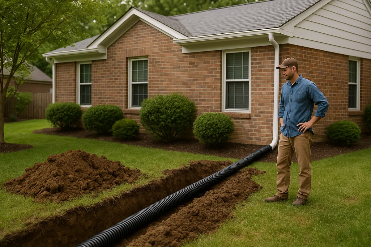
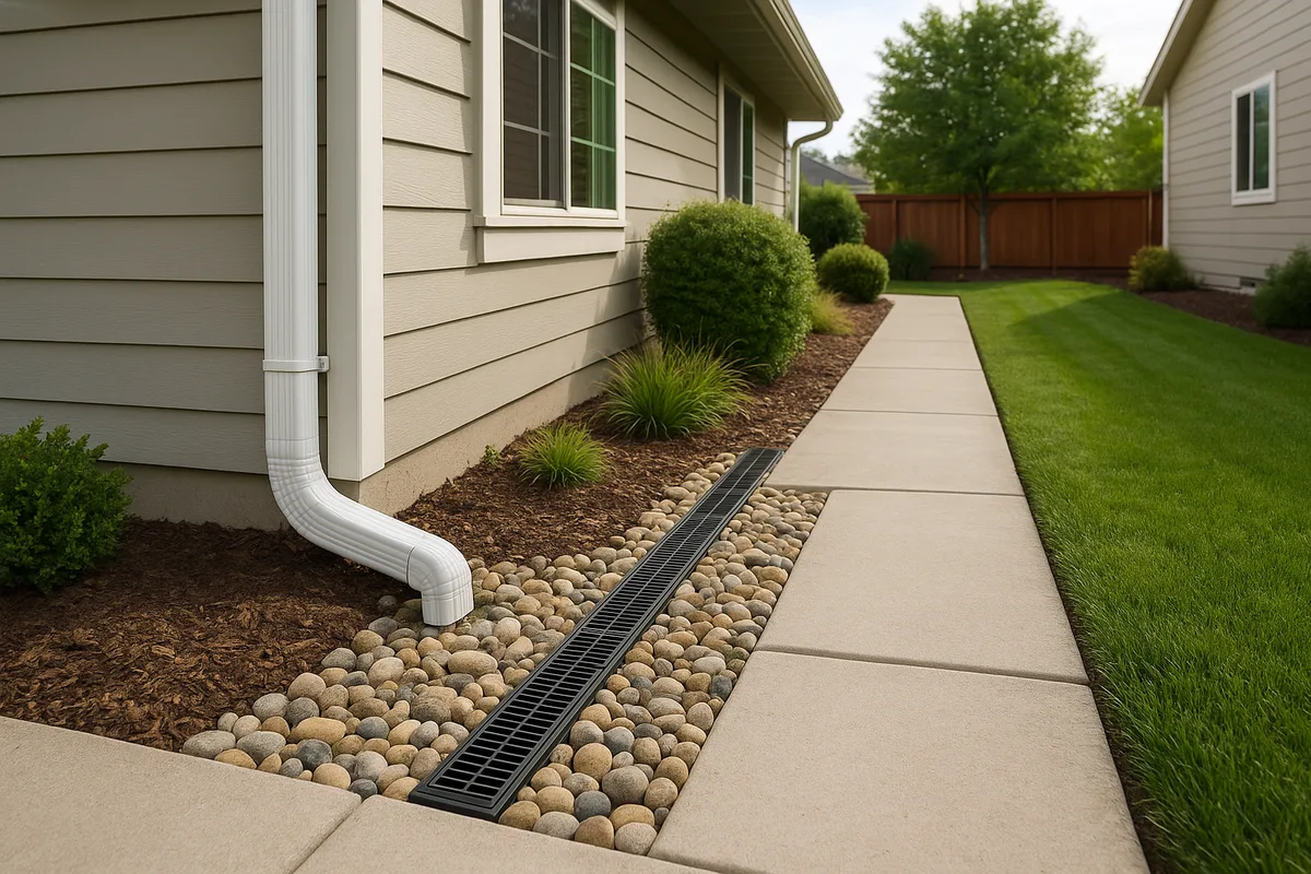
French Drains and Curtain Drains
French drains are probably the most commonly installed drainage solution in Oregon — and also the most commonly installed incorrectly. A proper French drain in Oregon clay soils requires:
- Adequate depth: The drain must be installed below the level of the problem. For foundation drainage, this typically means the bottom of the drain pipe sits at or below the bottom of the footing. For yard drainage, 18-24 inches is typical.
- Proper aggregate: Clean, washed 3/4-inch to 1-1/2-inch drain rock. Do NOT use crushed rock with fines — the fines will migrate into the pipe and clog it within a few years.
- Filter fabric: Non-woven geotextile fabric wrapping the entire aggregate column is essential in Oregon's silty soils. Without it, fine soil particles migrate into the aggregate and reduce permeability over time. NDS provides excellent technical resources on proper French drain construction.
- Adequate pipe size: 4-inch perforated pipe is the minimum for residential applications. For properties managing significant water volume, 6-inch pipe is preferred.
- Positive outlet: The drain must discharge somewhere — to a storm drain (with permission from the local jurisdiction), to daylight on a slope, or to a dry well or infiltration facility. A French drain with no outlet is just an underground puddle.
Curtain drains (also called interceptor drains) are installed uphill of a structure to intercept subsurface water flowing downslope before it reaches the foundation. These are particularly effective on Portland's West Hills properties and hillside lots throughout the Willamette Valley.
Interior Drainage Systems
For Oregon homes with chronic basement water intrusion that can't be resolved with exterior grading and drainage alone, interior drainage systems are often the most practical solution. These systems involve:
- Cutting a channel in the basement floor along the perimeter
- Installing perforated drain pipe in a gravel bed below the slab
- Collecting water in a sump pit with a pump that discharges to the exterior
- Applying a waterproof membrane to interior foundation walls
Interior systems are common in Portland's older neighborhoods — Irvington, Alameda, Laurelhurst, Sellwood — where homes built in the early 1900s have rubble stone or unreinforced concrete foundations that can't be effectively waterproofed from the exterior without excavation that would damage mature landscaping and neighboring structures.
Crawl Space Moisture Management
Oregon has an enormous number of homes with crawl spaces, and crawl space moisture is arguably the state's most pervasive residential drainage issue. Effective crawl space moisture management in Oregon typically requires a multi-component approach:
- Vapor barrier: A heavy-duty (12-20 mil) polyethylene vapor barrier covering the entire crawl space floor, sealed at seams and attached to foundation walls. This prevents soil moisture from evaporating into the crawl space.
- Perimeter drainage: If water is entering the crawl space through the foundation or from surface water, a perimeter French drain inside the crawl space directing to a sump pump.
- Ventilation management: Oregon's building code allows both vented and sealed (conditioned) crawl spaces. Sealed crawl spaces with dehumidification are generally more effective at controlling moisture in Oregon's climate, though they require careful design and ongoing maintenance.
- Gutter and downspout management: Ensuring all roof water is directed well away from the crawl space perimeter.
Rain Gardens and Bioswales
Oregon has been a national leader in green infrastructure for stormwater management, and rain gardens are both encouraged and sometimes required by local jurisdictions. A rain garden is a shallow, planted depression designed to capture and infiltrate stormwater runoff. The American Society of Landscape Architects has highlighted Portland's green infrastructure program as a model for other cities.
In Oregon's clay soils, rain gardens must be designed with amended soil mixes (typically 60% sand, 20% compost, 20% topsoil) to achieve adequate infiltration rates. The native clay soil below the rain garden may require an underdrain — a perforated pipe at the bottom of the rain garden that connects to the storm system — to prevent prolonged ponding.
Portland's Bureau of Environmental Services provides technical guidance and, in some cases, financial incentives for residential rain garden installation. Eugene's stormwater program similarly encourages green infrastructure approaches. The Low Impact Development Center offers design guidance applicable to Oregon conditions.
Dry Wells and Infiltration Facilities
Dry wells (also called soakaway pits) are underground chambers filled with aggregate that receive stormwater and allow it to infiltrate into the surrounding soil. They're common in Oregon, particularly for managing roof runoff.
However, dry wells in Oregon's clay soils have a mixed track record. In well-drained soils (sandy loam, volcanic ash), they work well. In clay soils, they can fill during the wet season and fail to drain between storm events, essentially becoming underground ponds that contribute to foundation problems rather than solving them. Before installing a dry well in western Oregon, a percolation test is essential to verify that the surrounding soil can actually accept the water.
Sump Pumps
Sump pumps are a fact of life for thousands of Oregon homeowners. For properties with high water tables or persistent groundwater intrusion, a sump pump is often the most reliable solution. Key considerations for Oregon installations:
- Battery backup is essential. Oregon's wet season storms frequently cause power outages, and that's exactly when your sump pump is working hardest. A battery backup system or water-powered backup pump is not optional — it's critical.
- Discharge location matters. Sump pump discharge must be directed away from the foundation and should not create problems for neighboring properties. Most Oregon jurisdictions prohibit sump pump discharge to the sanitary sewer.
- Sizing: The pump must be sized for the volume of water it needs to handle. A pump that cycles every few minutes during heavy rain is undersized.
- Maintenance: Sump pumps have a typical lifespan of 7-10 years. Annual testing and inspection are essential, ideally before the wet season begins in October.
Cost Considerations for Oregon Drainage Projects
Drainage improvement costs in Oregon vary significantly by region, scope, and soil conditions. As of 2026, typical cost ranges for common residential drainage projects include:
Grading corrections (foundation perimeter): $1,500 - $5,000 for a typical single-family home. This is often the highest-value investment — relatively low cost with significant impact.
French drain installation: $25 - $50 per linear foot for a standard 18-24 inch deep French drain. A typical 100-foot run costs $2,500 - $5,000. Deeper drains (for foundation footing drainage) run $40 - $75 per linear foot.
Interior basement waterproofing system: $8,000 - $20,000 depending on basement size and water volume. This includes perimeter drain, sump pump, and wall membrane.
Crawl space encapsulation with drainage: $5,000 - $15,000 depending on crawl space size and whether a sump pump and dehumidifier are required.
Rain garden installation: $1,500 - $5,000 for a professionally designed and installed residential rain garden. DIY installations can be done for $300 - $800 in materials.
Sump pump installation: $1,000 - $3,000 for a primary pump with battery backup.
Retaining wall drainage repair: $3,000 - $15,000+ depending on wall size and accessibility. This is one of the most expensive drainage repairs because it often requires partial or complete wall reconstruction.
Complete lot re-grading: $5,000 - $15,000 for significant grading changes on a typical residential lot.
Oregon labor costs for drainage work tend to be higher in the Portland metro area and lower in rural areas and smaller cities. The wet season (October-May) is both the busiest time for drainage contractors and the most difficult time to perform earthwork, which can affect pricing and scheduling. For property damage caused by flooding or drainage failures, the SBA offers disaster loans that can help cover repair and mitigation costs.
Seasonal Timing for Oregon Drainage Work
The Ideal Window: June Through September
The vast majority of drainage construction in Oregon should be scheduled during the dry season. The reasons are practical:
- Soil workability: Clay soils that are plastic and unworkable when wet become firm and excavatable when dry.
- Erosion control: Exposed soil during the dry season doesn't erode. The same exposed soil during a November rainstorm can wash away overnight — and Oregon's erosion control regulations require costly best management practices for any ground disturbance during the wet season.
- Compaction: Proper soil compaction is nearly impossible in saturated conditions. Fill placed in wet soil will settle unpredictably.
- Access: Heavy equipment on wet Oregon clay creates ruts, compacts soil beyond recovery, and can damage neighboring properties.
Emergency and Off-Season Work
Sometimes drainage problems can't wait for summer. Active basement flooding, failing retaining walls, and landslide risk may require immediate intervention. Off-season drainage work in Oregon requires:
- Erosion control measures (silt fencing, straw wattles, inlet protection)
- Dewatering equipment to manage groundwater during excavation
- Temporary stabilization of exposed soil
- Potentially higher costs due to difficult working conditions
Pre-Season Preparation: September and October
The weeks before the wet season begins are critical for Oregon property owners:
- Clean gutters and downspouts. Oregon's deciduous trees drop leaves in October just as the rains begin — a recipe for gutter clogs and overflow.
- Test sump pumps. Pour water into the pit and verify the pump activates, runs properly, and discharges correctly.
- Inspect and clear drainage outlets. French drain outlets, yard drain catch basins, and swale outlets can become blocked by vegetation and debris during the dry season.
- Check grading. Walk the foundation perimeter and verify that soil still slopes away from the structure. Settling, landscaping, and root growth can alter grades over time.
- Inspect crawl space. Verify the vapor barrier is intact, vents are functioning (or sealed, if the crawl space is conditioned), and no water is present.
The Irrigation Association provides useful resources on integrating drainage maintenance with overall landscape water management — relevant for Oregon properties that irrigate during the dry season.
When to Get Professional Help
Many Oregon drainage problems can be diagnosed and even addressed by knowledgeable homeowners. But certain situations demand professional expertise:
Structural concerns: If you see foundation cracks wider than 1/4 inch, bowing basement walls, or tilting retaining walls, these indicate structural loads from water pressure that require engineering assessment. The American Society of Civil Engineers maintains directories of licensed professionals.
Hillside properties with slope instability: Any sign of ground movement — cracked driveways, tilting fences, doors that suddenly won't close — on a hillside property requires immediate professional evaluation. Oregon has tragically demonstrated the consequences of ignored slope drainage, with landslides causing property damage and loss of life.
Persistent water intrusion despite corrections: If you've addressed grading, gutters, and surface drainage and still have water intrusion, the problem likely involves groundwater or subsurface conditions that require professional investigation.
Properties in or near flood zones: If your property is in or near a FEMA flood zone, professional flood risk assessment and mitigation planning can save tens of thousands of dollars in potential damage. FEMA's preparedness resources provide baseline guidance, but site-specific assessment is essential.
Disputes with neighbors over drainage: Oregon law generally follows the "civil law rule" for surface water drainage, meaning a property owner cannot alter natural drainage patterns in a way that damages a neighboring property. Drainage disputes can become legal disputes quickly, and professional documentation of drainage conditions is invaluable.
Septic system interactions: Properties with septic systems, particularly in Central and Eastern Oregon, must carefully manage the relationship between stormwater drainage and the septic drain field. Professional design is essential to avoid system failure and groundwater contamination.
Special Considerations for Oregon Real Estate Transactions
Drainage is one of the most consequential — and most frequently overlooked — factors in Oregon real estate transactions. For buyers, sellers, and real estate professionals:
For Buyers
- Never rely solely on a standard home inspection for drainage assessment. Home inspections are conducted on a single day, often during dry conditions, and cannot evaluate how a property performs during the wet season.
- Request drainage-specific disclosures. Ask the seller directly about wet season water intrusion, sump pump operation, crawl space moisture, and any drainage work performed.
- Check flood zone status independently. Don't rely on the seller's disclosure — verify through FEMA maps and local floodplain management offices.
- Investigate the neighborhood. Drive through the area during a rainstorm. Talk to neighbors. Look for signs of widespread drainage problems — water stains on foundations, sump pump discharge pipes, and erosion patterns.
For Sellers
Addressing known drainage issues before listing is almost always more cost-effective than dealing with them during negotiations or, worse, in post-sale litigation. Oregon courts have held sellers liable for failure to disclose known drainage problems, and the cost of remediation plus legal fees far exceeds the cost of proactive repair.
For Real Estate Professionals
Drainage problems are among the leading causes of post-sale disputes in Oregon. Recommending independent drainage assessment — particularly for properties with basements, crawl spaces, hillside locations, or proximity to waterways — protects both your clients and your professional reputation.
The Water Environment Federation and National Association of Flood and Stormwater Management Agencies both provide resources on stormwater management best practices that can help real estate professionals understand the scope of drainage issues.
Oregon's Changing Climate and Future Drainage Challenges
Oregon's drainage challenges are intensifying. Climate projections for the Pacific Northwest indicate:
- Increased precipitation intensity: More rain falling in shorter, more intense bursts, even as total annual precipitation may not change dramatically. This means drainage systems designed for steady, moderate rainfall will be increasingly overwhelmed.
- Warmer winters with more rain, less snow: The Cascades snowpack that historically stored water and released it gradually through spring is declining. More precipitation falling as rain means more immediate runoff during the wet season.
- Longer, drier summers: Extended drought periods will increase soil shrinkage, widen foundation gaps, and create harder, more impermeable soil surfaces that resist infiltration when rains return.
- Sea level rise and coastal flooding: Coastal communities face increasing tidal flooding, storm surge, and groundwater rise that will compound existing drainage challenges.
For property owners, this means drainage infrastructure installed today should be designed with capacity beyond current conditions. Oversizing pipes, increasing detention volume, and building in redundancy (such as backup sump pumps) are prudent investments.
Organizations like American Rivers advocate for watershed-scale approaches to stormwater management that complement individual property improvements — recognizing that residential drainage is part of a larger system.
Get a Drainage Intelligence Report™ for Your Oregon Property
Oregon's combination of seasonal rainfall extremes, volcanic and clay soils, complex topography, and evolving regulations makes drainage assessment both critically important and genuinely difficult. A quick visual inspection can't tell you what your soil's permeability rate is, whether your property sits on a perched water table, or how upstream development is changing the runoff patterns that affect your land.
A Drainage Intelligence Report™ from Low Point Labs provides the comprehensive, data-driven assessment that Oregon property owners need. Using topographic analysis, soil data, precipitation modeling, flood risk evaluation, and regulatory context specific to your property's location, a Drainage Intelligence Report™ gives you:
- Detailed drainage risk assessment based on your property's specific soil type, slope, and position in the watershed
- Identification of current and potential drainage vulnerabilities including foundation exposure, surface water accumulation zones, and subsurface water risks
- Regulatory context including flood zone status, stormwater management requirements, and disclosure obligations
- Actionable recommendations prioritized by impact and cost-effectiveness
- Documentation suitable for real estate transactions, insurance purposes, and contractor guidance
Whether you're buying a home in Portland's East Side, maintaining a property in Eugene's Amazon Creek corridor, building in Bend's volcanic soils, or evaluating flood risk on the coast, a Drainage Intelligence Report™ transforms uncertainty into actionable intelligence.
Don't wait for the next atmospheric river to discover your property's drainage vulnerabilities. Get your Drainage Intelligence Report™ from Low Point Labs today.
Explore our US Drainage Guide for a national perspective on residential drainage.
Frequently Asked Questions
Subscribe to generate reports on demand. Cancel anytime.