The State Where Water Runs the Show
Florida is, in many ways, barely land at all. The entire peninsula sits on a porous limestone platform that rises, at its highest natural point, only 345 feet above sea level — and the vast majority of residential development sits below 25 feet. The state's average elevation is the lowest of any in the nation. Combine that with 54 inches of average annual rainfall, a water table that frequently sits within inches of the surface, and roughly 1,350 miles of coastline, and you get a state where drainage isn't just an engineering concern — it's the foundational challenge of habitation itself.
What makes Florida's drainage situation genuinely unique is the paradox at its core: the state's dominant sandy soils are among the most permeable in the country, yet Florida experiences some of the worst residential flooding and water management failures anywhere in the United States. The reason is that permeability means nothing when the ground is already saturated. During a typical summer afternoon thunderstorm, three inches of rain can fall in under an hour. If the water table is already at 18 inches below grade — common across South Florida, much of the Gulf Coast, and Central Florida's lake country — that rain has nowhere to go. The sand that drains beautifully in January becomes a waterlogged sponge in August.
This guide covers the specific drainage realities Florida property owners face today, from the regulatory environment shaped by decades of hard lessons, to the soil and hydrological conditions that make every lot a potential water management challenge, to the practical solutions that actually work in this state's unique conditions.
Florida's Drainage Landscape: Geology, Soils, and Water
The Limestone Foundation
Everything about Florida drainage starts with what's underneath. The entire state sits atop the Florida Platform, a massive carbonate shelf composed primarily of limestone, dolostone, and other soluble rock. This matters enormously for drainage because limestone is riddled with dissolution features — sinkholes, underground channels, caverns, and voids created by millennia of slightly acidic groundwater dissolving the rock. The USGS classifies Florida as having one of the most extensive karst landscapes in the world.
For homeowners, the karst geology creates two simultaneous problems. First, the underground voids and channels mean that groundwater moves in unpredictable ways. Water that enters the ground on your property might travel laterally through a limestone conduit and emerge as a spring in your neighbor's yard — or vice versa. Second, sinkholes are an ever-present risk, particularly in the "Sinkhole Alley" corridor running from Pasco County through Hernando and Citrus Counties. Aggressive drainage modifications — especially those that concentrate water infiltration in a single location — can accelerate sinkhole formation by dissolving the limestone more rapidly.
Soil Types Across the State
Florida's soils are far more varied than the "it's all sand" stereotype suggests, and understanding your specific soil type is critical for drainage planning. The USDA Web Soil Survey is an indispensable tool for any Florida property owner, providing parcel-level soil data that directly affects drainage design.
Fine Sands and Sandy Soils (Most of the Peninsula) The Myakka series — Florida's official state soil — is a fine sand with a distinctive feature called a spodic horizon: a hardpan layer of organic matter and aluminum that forms 18 to 30 inches below the surface. This hardpan acts as a near-impermeable barrier, creating a perched water table above it even when the regional water table is lower. Water infiltrates quickly through the top layer of sand, hits the spodic horizon, and pools. This is why you'll see standing water in a sandy yard after heavy rain — the sand drained perfectly, but the water has nowhere to go once it hits the hardpan.
Other common sandy soil series include the Immokalee, Pomello, and St. Johns soils, each with slightly different hardpan depths and drainage characteristics. In the Ridge region running down the center of the peninsula — through Lake Wales, Avon Park, and Sebring — the deep, well-drained Astatula and Tavares sands lack the spodic horizon and drain exceptionally well. Properties on Ridge soils rarely have surface drainage problems, though they can contribute to aquifer vulnerability.
Muck and Organic Soils (Everglades Agricultural Area, Lake Apopka Basin, St. Johns River Marshes) South of Lake Okeechobee and in scattered wetland basins throughout the state, thick organic muck soils — primarily the Pahokee and Torry series — present extreme drainage challenges. These soils have very high water-holding capacity and are prone to subsidence (literally shrinking and oxidizing when drained). Communities built on former muck lands, including parts of western Palm Beach County and areas around Lake Apopka in Orange County, deal with chronic settling, seasonal flooding, and soil that can become hydrophobic when dried out.
Marl and Limestone-Derived Soils (Miami-Dade, Monroe County, Parts of the Keys) In southeastern Florida, a thin layer of marl — calcium carbonate mud — sits directly over the Miami Limestone formation. These soils are poorly drained, alkaline, and extremely shallow. In parts of Miami-Dade County, you can hit solid limestone with a shovel at six inches below grade. This makes traditional drainage solutions like French drains nearly impossible to install without specialized rock-cutting equipment.
Clay-Bearing Soils (North Florida and Panhandle) North of Gainesville, Florida's geology transitions from the carbonate platform to soils with significant clay content, including the Orangeburg, Norfolk, and Tifton series. The Panhandle region from Pensacola through Tallahassee has soils that behave more like Georgia and Alabama — with genuine clay layers that swell, shrink, and create the kind of surface drainage challenges more commonly associated with the Gulf Coast states. Property owners in Jacksonville, Tallahassee, and the Panhandle deal with a fundamentally different drainage calculus than those in Tampa or Miami.
The Water Table: Florida's Defining Drainage Factor
No single factor dominates Florida drainage more than the water table. In much of the state, the seasonal high water table sits within two to four feet of the surface — and in many areas, it's within 12 inches. The USDA Natural Resources Conservation Service publishes seasonal high water table data for every mapped soil series, and this information should be the starting point for any drainage assessment.
The water table in Florida is not static. It fluctuates dramatically between the wet season (June through October) and the dry season (November through May). A property that appears perfectly drained in March may have water seeping into the garage slab in September. This seasonal swing can be three feet or more in sandy soils and is the single most common reason Florida homeowners are surprised by drainage problems — they bought the house in the dry season.
The Biscayne Aquifer, which underlies all of Miami-Dade, Broward, and southern Palm Beach Counties, is one of the most permeable aquifers in the world. It's essentially a Swiss cheese of limestone voids filled with water. The aquifer's surface is so close to ground level that canal systems — managed by the South Florida Water Management District — must actively pump water to keep the water table low enough for habitation. When those systems are overwhelmed during major rain events, entire neighborhoods can flood from below as the water table literally rises through the ground.
Climate Patterns and Their Drainage Implications
The Wet Season Reality
Florida's rainfall pattern is sharply seasonal and intensely concentrated. Roughly 60-65% of the state's annual precipitation falls between June and September. But the raw annual average of 54 inches obscures the real drainage challenge: intensity. Florida leads the continental United States in rainfall intensity, with NOAA data showing that the state regularly experiences rainfall rates exceeding four inches per hour during summer convective storms.
These aren't gentle, soaking rains. A typical summer afternoon thunderstorm in Orlando, Tampa, or Miami can dump two to four inches in 45 minutes over an area of just a few square miles. Drainage systems must be designed for these peak events, not for average conditions. A system that handles one inch per hour — adequate for most of the eastern United States — will be overwhelmed within minutes during a Florida summer storm.
Tropical Systems and Named Storms
Beyond the daily convective storms, Florida's hurricane and tropical storm exposure creates drainage events of an entirely different magnitude. The National Weather Service tracks these systems, but the drainage implications extend far beyond wind damage. Hurricane Ian (2022) dropped over 20 inches of rain on parts of Central Florida, causing catastrophic freshwater flooding in areas like North Port and Fort Myers that were miles from any storm surge. Hurricane Irma (2017) saturated the entire peninsula. These events exposed the inadequacy of drainage infrastructure across the state and led directly to updated stormwater standards in many jurisdictions.
The critical lesson for property owners: your drainage system needs to handle not just typical summer storms but also the prolonged, multi-day rainfall that tropical systems deliver. A property that manages three inches in an hour might still flood when it receives 12 inches over 36 hours, because the water table rises to the surface and eliminates all subsurface storage capacity.
Sea Level Rise and Tidal Flooding
Florida is ground zero for sea level rise impacts on residential drainage. NOAA's Office for Coastal Management documents that sea levels along Florida's coastline have risen approximately 8 inches since 1950, with the rate accelerating. For coastal communities, this means that gravity-based drainage systems — which rely on water flowing downhill to outfalls at sea level — are losing their hydraulic head. When the tide is high and the ocean is higher than it used to be, stormwater literally cannot drain.
This is already a lived reality in Miami Beach, where the city has spent over $500 million on raised roads and pump stations. It's increasingly affecting Fort Lauderdale's barrier island communities, St. Augustine's historic district, the Tampa Bay shoreline, and low-lying neighborhoods in Jacksonville along the St. Johns River. King tide events — the highest astronomical tides of the year — now routinely push saltwater up through storm drains and into streets in these communities, even on sunny days.
For property owners in coastal Florida, drainage assessment must now account for future conditions, not just current ones. A system designed to drain to a canal that's at current sea level may be functionally useless within 15-20 years as that canal's baseline water level rises.
Florida's Regulatory Environment for Drainage
Water Management Districts: The Primary Regulators
Florida's stormwater management is governed primarily through five Water Management Districts (WMDs), each with jurisdiction over major watershed basins. These are not advisory bodies — they have regulatory authority over any development activity that affects surface water, and their permits are required for most drainage modifications that exceed routine maintenance:
- South Florida Water Management District (SFWMD): Covers the entire southern third of the state, from Orlando south through the Keys. Manages the Central & Southern Florida Flood Control system, including the massive canal and levee network that makes habitation possible in much of South Florida.
- Southwest Florida Water Management District (SWFWMD, "Swiftmud"): Covers the Tampa Bay area, Sarasota, and the Nature Coast. Particularly active in regulating stormwater ponds and wetland impacts.
- St. Johns River Water Management District (SJRWMD): Covers northeast and east-central Florida, including Jacksonville, Daytona Beach, and parts of Orlando. Manages the St. Johns River basin, one of the few north-flowing rivers in the country.
- Suwannee River Water Management District (SRWMD): Covers north-central Florida, including Gainesville and the Springs region.
- Northwest Florida Water Management District (NWFWMD): Covers the Panhandle from Pensacola to Tallahassee.
For residential property owners, the key regulatory threshold is typically whether your project exceeds a certain impervious surface threshold or disturbs more than a specified acreage. Individual homeowners doing routine yard drainage improvements generally don't need a WMD permit, but any project that involves filling wetlands, modifying a drainage easement, or connecting to the public stormwater system will trigger review. When in doubt, contact your local WMD — the consequences of unpermitted work affecting wetlands or waterways can be severe, including mandatory restoration at the property owner's expense.
Environmental Resource Permits (ERPs)
Florida's Environmental Resource Permit (ERP) program, administered jointly by the WMDs and the Florida Department of Environmental Protection (FDEP), is the primary permitting mechanism for activities that affect wetlands and surface waters. The EPA also maintains federal jurisdiction over wetlands under the Clean Water Act, meaning some projects require both state and federal permits — particularly those involving the U.S. Army Corps of Engineers Section 404 permits for dredge and fill activities in wetlands.
This is especially relevant in Florida because wetlands are everywhere. The state has approximately 11 million acres of wetlands — more than any state except Alaska. Many residential properties, particularly those in newer subdivisions built since the 1990s, include wetland buffers, conservation easements, or stormwater management areas that are legally protected. Modifying these areas — even seemingly minor actions like filling a low spot, clearing vegetation, or redirecting water — can violate your ERP conditions or your subdivision's stormwater management permit.
Local Ordinances and Building Codes
Beyond the WMDs, every Florida county and municipality has its own stormwater and grading ordinances. These vary significantly:
- Miami-Dade County requires that finished floor elevations be a minimum of one foot above the crown of the nearest road and mandates specific lot grading to direct water away from structures.
- Hillsborough County (Tampa) requires stormwater management plans for any development that creates more than 4,000 square feet of impervious surface.
- Duval County (Jacksonville) has specific regulations for development within the St. Johns River floodplain, including compensatory storage requirements.
- Lee County (Fort Myers) updated its stormwater standards significantly after Hurricane Ian, including higher design storm requirements for new construction.
The Florida Building Code, which applies statewide, includes requirements for minimum finished floor elevations relative to the base flood elevation (BFE) in FEMA-designated flood zones. Most Florida communities participate in the National Flood Insurance Program, and many have adopted standards that exceed FEMA minimums — requiring one to two feet of freeboard above the BFE.
Disclosure Requirements
Florida law requires sellers to disclose known material defects, which includes known drainage problems, flooding history, and water intrusion. The standard Florida Realtors/Florida Bar residential sale contract includes specific questions about flood zone status, flood insurance requirements, and past flooding. The Department of Housing and Urban Development also requires flood zone disclosure for federally-backed mortgages.
However, Florida does not require a specific drainage inspection or report as part of a real estate transaction. This is a significant gap — many drainage problems are seasonal and may not be apparent during a standard home inspection conducted in the dry season. A property that looks perfectly dry in February may have six inches of standing water in the backyard every August. This is precisely the kind of hidden risk that a Drainage Intelligence Report™ is designed to uncover.
Diagnosing Drainage Problems on Your Florida Property
Visual Assessment: What to Look For
Florida drainage problems leave distinctive signatures that an informed property owner can learn to read. Walk your property during the wet season — ideally during or immediately after a heavy rain — and look for these indicators:
Surface Water Patterns
- Standing water that persists more than 24 hours after rain ends. In sandy soils, water should infiltrate within hours unless the water table is at or near the surface.
- Water flowing toward your foundation rather than away from it. Florida lots should be graded to drain away from the structure at a minimum slope of 2% (about ¼ inch per foot) for the first 10 feet.
- Erosion channels or rills in the yard, indicating concentrated flow that's cutting into the soil.
- Water stains or algae/mildew lines on the lower portion of exterior walls, fences, or landscape features.
Foundation and Structural Indicators
- Moisture or efflorescence (white mineral deposits) on concrete block walls, especially common in Florida's CBS (concrete block and stucco) construction.
- Cracks in the stucco or block that show stair-step patterns, which can indicate differential settlement from inconsistent soil moisture.
- Doors or windows that stick seasonally — swelling in the wet season and releasing in the dry season — can indicate foundation movement related to moisture cycling.
- Musty odors in the home, particularly in rooms closest to grade, suggesting moisture intrusion through the slab or block walls.
Landscape Indicators
- Patches of different grass species. In Florida, areas that stay wet tend to grow St. Augustine grass vigorously while Bahia grass thins out — or you may see sedges, rushes, or other wetland indicator plants colonizing low spots.
- Soil that stays spongy or soft well after rain has stopped.
- Mushrooms or fungal growth in the lawn, indicating persistent subsurface moisture.
- Trees showing stress (leaf drop, canopy thinning) despite adequate rainfall — this can indicate root zone saturation.
The Spodic Horizon Test
If your property is on one of Florida's common fine sand soils (Myakka, Immokalee, Pomello, or similar), you can check for the spodic horizon with a simple test. Using a post-hole digger or hand auger, dig down 18 to 36 inches. If you encounter a dark brown or black layer that's noticeably harder and more compact than the sand above it, that's the spodic horizon. Note the depth — this is effectively the bottom of your drainage capacity. Any French drain, dry well, or infiltration system installed above this layer will have limited effectiveness because the water can't pass through the hardpan.
Checking Your Water Table
The simplest way to determine your seasonal high water table is to dig a test hole 24 to 36 inches deep and observe it over several days during the wet season. If water seeps into the hole and stabilizes at a certain level, that's your current water table. Compare this to the seasonal high water table listed for your soil type in the Web Soil Survey — if the observed level is higher than the published data, it may indicate a localized drainage problem, a rising water table, or changes in the surrounding landscape that are directing more water to your property.
Checking Your Flood Zone Status
Every Florida property owner should know their FEMA flood zone designation. You can look this up on FEMA's Flood Map Service Center. Key designations to understand:
- Zone AE: The 100-year floodplain with a base flood elevation determined. Flood insurance is required for federally-backed mortgages. Significant building restrictions apply.
- Zone VE: Coastal high hazard area subject to wave action. The most restrictive building requirements.
- Zone X (shaded): The 500-year floodplain. Flood insurance is not required but is strongly recommended.
- Zone X (unshaded): Minimal flood risk as mapped. However, roughly 25-30% of Florida flood insurance claims come from properties in Zone X — a stark reminder that the maps don't capture all flood risk.
Florida's flood maps are updated periodically, and many areas are currently undergoing remapping. Your flood zone can change, and with it your insurance requirements and property value. FloodSmart.gov provides consumer-facing information about flood insurance options and the importance of coverage even outside designated flood zones.
Common Drainage Solutions for Florida Properties
Grading and Swale Maintenance
The most fundamental — and most frequently neglected — drainage solution in Florida is proper lot grading and swale maintenance. Most Florida subdivisions are designed with a swale system: shallow, grass-lined channels that run between properties and along road frontages, collecting and conveying stormwater to retention ponds, lakes, or the municipal storm sewer system.
These swales are part of the subdivision's permitted stormwater management system, and they only work if they're properly maintained. Over time, soil settles, grass thickens, homeowners add fill or landscaping, and the swales lose their capacity. In many Florida neighborhoods, the swales have been effectively destroyed by decades of incremental encroachment — fences built across them, driveways extended over them, landscaping that blocks flow.
If you have a swale on your property, you are typically responsible for maintaining it. This means:
- Keeping it mowed and free of debris
- Not filling it, blocking it, or building across it
- Maintaining the designed cross-section (typically a shallow V or U shape)
- Not diverting additional water into it beyond what the original design intended
Many Florida municipalities will issue code violations for blocked or filled swales, and some will perform the work and bill the property owner. Restoring a degraded swale is one of the most cost-effective drainage improvements you can make — often just a few hundred dollars for regrading, versus thousands for engineered solutions.
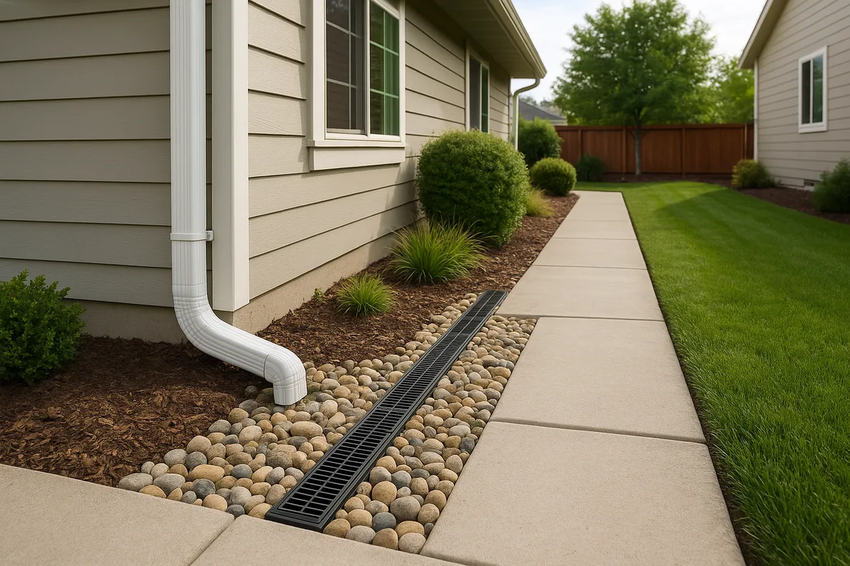
French Drains and Curtain Drains
French drains — perforated pipes in gravel-filled trenches — are a staple of residential drainage nationwide, but they require careful adaptation for Florida conditions. The key limitations in Florida:
Water Table Constraint: A French drain can only drain to a level above the water table. If your water table is at 18 inches and your French drain is at 12 inches, it will work. If the water table rises to 12 inches during the wet season, the French drain becomes a pipe sitting in groundwater and does nothing. In much of South Florida, this makes traditional French drains ineffective during the months when you need them most.
Outfall Requirement: Every French drain needs somewhere to discharge. In Florida, this is typically a swale, retention pond, canal, or dry well. You cannot discharge onto a neighbor's property or into a wetland without permission and potentially permits.
Material Selection: Florida's sandy soils can migrate into French drain systems if proper filter fabric isn't used. Use non-woven geotextile fabric wrapped around the entire gravel-and-pipe assembly. Avoid "sock" pipe (pipe with a fabric sleeve) as the sole filtration — it clogs faster than a properly constructed system with fabric around the entire trench. Products from manufacturers like NDS are widely available at Florida home improvement stores and offer residential-grade drainage components designed for these applications.
Depth Considerations: In areas with a spodic horizon, the French drain should ideally be installed below the hardpan to allow water to drain into the deeper sand layer. This may require trenching to 30-36 inches rather than the typical 12-18 inches used in other states.
Dry Wells and Infiltration Systems
Dry wells — underground chambers that collect water and allow it to slowly infiltrate into the surrounding soil — can be effective in Florida's sandy soils, but only where the water table provides sufficient clearance. A dry well needs a minimum of two feet of separation between the bottom of the well and the seasonal high water table to function.
In the Ridge region, deep sand areas of the Panhandle, and well-drained portions of Northeast Florida, dry wells work exceptionally well. In coastal areas, low-lying interior areas, and anywhere with a high water table, they're essentially useless — you'd be installing a well that fills with groundwater before any stormwater reaches it.
Stormwater Ponds and Retention Systems
Florida has more stormwater retention ponds than any other state — they're the ubiquitous water features that define virtually every subdivision built since the 1980s. These ponds are engineered systems, not decorative amenities, and they serve a critical function: storing stormwater runoff from the development and releasing it slowly to prevent downstream flooding.
If your property is in a community with a stormwater pond, understand that:
- The pond is part of a permitted system maintained by your HOA, CDD (Community Development District), or municipality
- The pond has a designed normal water level and a designed high water level — water rising above the normal level during storms is expected and normal
- The outfall structure (typically a weir, orifice, or control structure) regulates discharge and must not be modified
- The littoral shelf (the shallow planted area around the pond's edge) is required by permit and must be maintained with appropriate vegetation — it provides water quality treatment
- Erosion of the pond bank adjacent to your property is typically your responsibility or the HOA's, depending on your community's governing documents
Sump Pumps and Dewatering Systems
In areas where gravity drainage is impossible due to flat terrain and high water tables, mechanical pumping may be the only solution. Sump pumps are common in Florida homes with below-grade features (which are rare but do exist in some North Florida homes) and are increasingly used to manage water intrusion in slab-on-grade homes where the water table rises above the slab level.
Dewatering systems — more sophisticated setups that use well points or perimeter drains connected to pumps — are used in some South Florida communities to keep the water table below foundation level. These are expensive to install and operate, and they require ongoing maintenance and power. They also raise environmental concerns, as the pumped water must be discharged somewhere and may carry sediment or contaminants.
Green Infrastructure and Low Impact Development
Florida is increasingly embracing green infrastructure approaches to stormwater management, driven by both regulatory requirements and practical necessity. The Low Impact Development Center provides extensive guidance on these techniques, many of which are well-suited to Florida's climate and soils:
Rain Gardens: Shallow, planted depressions designed to capture and infiltrate stormwater. In Florida's sandy soils, rain gardens can be highly effective — the challenge is selecting plants that tolerate both the saturated conditions during rain events and the dry conditions between events. Native species like muhly grass, blue flag iris, swamp sunflower, and coreopsis are excellent choices. The American Society of Landscape Architects maintains resources on designing these systems for residential properties.
Permeable Pavement: Pavers, porous concrete, or porous asphalt that allow water to infiltrate through the surface rather than running off. These are particularly effective for driveways, patios, and walkways in Florida, where the sandy subgrade provides excellent drainage beneath the pavement. Several Florida municipalities, including Duval County, now offer stormwater utility fee credits for properties that install permeable pavement.
Rain Barrels and Cisterns: Capturing roof runoff for later irrigation use. In Florida's wet season, a 2,000-square-foot roof generates approximately 1,200 gallons of runoff per inch of rain. Capturing even a fraction of this reduces the load on your drainage system and provides free irrigation water for the dry season. Some Florida counties and municipalities offer rebates or free rain barrels.
Bioswales: Engineered vegetated channels that slow, filter, and infiltrate stormwater. These are essentially enhanced versions of traditional swales, with specific soil mixes and plantings designed to maximize water quality treatment and infiltration.
Regional Drainage Challenges Across Florida
South Florida (Miami-Dade, Broward, Palm Beach)
South Florida's drainage challenges are the most acute and complex in the state. The region sits on the Biscayne Aquifer — incredibly porous limestone that makes the water table essentially continuous with the canal system. The entire region's drainage depends on an engineered network of canals, levees, water control structures, and pump stations managed by SFWMD. When this system is overwhelmed — as it was during the October 2024 rain event that dumped over 20 inches on parts of Broward County — flooding can be sudden and severe.
The shallow limestone makes traditional subsurface drainage nearly impossible in many areas. You can't dig a French drain when you hit rock at six inches. Drainage solutions in South Florida tend to rely on surface grading, pump systems, and connection to the canal network. The ongoing challenge of sea level rise is reducing the effectiveness of gravity-based drainage throughout the region, and saltwater intrusion into the Biscayne Aquifer threatens both water supply and the structural integrity of the limestone itself.
Neighborhoods particularly vulnerable include: Sweetwater and Hialeah (extremely flat, surrounded by canals that back up), Hallandale Beach and Hollywood (low elevation, tidal flooding), western Delray Beach and Boca Raton (former agricultural land with muck soils), and virtually all barrier island communities.
Central Florida (Orlando, Lakeland, Kissimmee)
Central Florida's drainage landscape is defined by its lakes — over 7,800 named lakes in the region — and the karst geology that created them. Many of Central Florida's lakes are actually sinkholes that filled with water, and the region's drainage is heavily influenced by the underground conduits that connect surface water to the Floridan Aquifer.
The Orlando metropolitan area has experienced explosive growth, with vast areas of former citrus groves and wetlands converted to residential development. While modern subdivisions are required to include stormwater management systems, the cumulative effect of development has increased impervious surface area dramatically, sending more water into a system that was already at capacity. The Shingle Creek, Boggy Creek, and Econlockhatchee River watersheds all show increased flooding frequency compared to pre-development conditions.
Central Florida's sandy soils generally drain well, but the spodic horizon creates perched water tables that surprise homeowners. Properties in Osceola, Polk, and southern Orange Counties frequently deal with wet-season flooding in areas that appear bone-dry during the winter.
Tampa Bay Area (Hillsborough, Pinellas, Pasco, Manatee)
The Tampa Bay region faces a combination of coastal flooding, river flooding (particularly along the Hillsborough and Alafia Rivers), and the unique challenge of Pinellas County — the most densely populated county in Florida, built almost entirely on a peninsula with minimal elevation and virtually no room for additional stormwater infrastructure.
Pasco County, north of Tampa, sits squarely in Sinkhole Alley, and drainage decisions here must account for sinkhole risk. Concentrating stormwater infiltration — through dry wells, large French drains, or retention areas — can accelerate sinkhole development in areas underlain by shallow limestone. The county requires geotechnical assessments for many types of development, and homeowners should exercise caution with any drainage solution that concentrates water infiltration in a single location.
The Tampa Bay area also experiences significant tidal influence on drainage. Storm drains in low-lying areas of South Tampa, Shore Acres in St. Petersburg, and Davis Islands can back up during high tide events, and this problem is worsening with sea level rise.
Northeast Florida (Jacksonville, St. Augustine)
Jacksonville — the largest city by area in the contiguous United States — straddles the lower St. Johns River and its numerous tributaries. The St. Johns is one of the laziest rivers in North America, dropping only 27 feet over its 310-mile length, which means it drains slowly and is heavily influenced by tides well upstream. During heavy rain events combined with high tides, the river essentially stops flowing and backs up into tributary creeks and drainage systems throughout Duval County.
St. Augustine, one of the lowest-lying cities in Florida, experiences regular tidal flooding in its historic district and along the Matanzas River. The city's centuries-old infrastructure was never designed for current water levels, and adaptation is an ongoing challenge.
Northeast Florida's soils include more clay content than the rest of the peninsula, particularly in the western portions of Duval, Clay, and St. Johns Counties. This creates surface drainage challenges more similar to Georgia than to typical Florida conditions.
The Panhandle (Pensacola, Tallahassee, Panama City)
The Panhandle receives the most rainfall in Florida — Pensacola averages over 65 inches annually — and has soils with significant clay content that resist infiltration. This combination creates aggressive surface runoff and erosion challenges that are uncommon in peninsular Florida.
The region is also more exposed to slow-moving tropical systems that can produce prolonged rainfall. Hurricane Sally (2020) stalled over the Pensacola area and dropped over 30 inches of rain in 24 hours, causing catastrophic flooding along Bayou Texar and throughout the urban core. The American Rivers organization has highlighted the Panhandle's river systems as particularly vulnerable to development-driven flooding.
Tallahassee sits at one of the higher elevations in Florida (approximately 200 feet) and has a rolling topography unusual for the state. Drainage here involves managing water flowing downhill through red clay soils — a fundamentally different challenge than the flat, sandy conditions elsewhere in Florida.
Costs of Drainage Solutions in Florida
Drainage improvement costs in Florida vary significantly by region, soil type, and the complexity of the problem. As of 2026, expect the following ranges:
| Solution | Typical Cost Range | Notes |
|---|---|---|
| Swale regrading (per linear foot) | $5-15 | Most cost-effective first step |
| French drain installation (per linear foot) | $25-60 | Higher in rocky/limestone areas |
| Dry well (per unit) | $800-2,500 | Only viable where water table allows |
| Sump pump system | $1,500-4,000 | Including basin, pump, and discharge line |
| Rain garden (typical residential) | $1,500-5,000 | Including plants, soil amendment, grading |
| Permeable paver driveway | $12-25 per sq ft | Compared to $8-15 for standard pavers |
| Lot regrading (typical residential lot) | $2,000-8,000 | Depends on extent and access |
| Stormwater pond bank repair | $3,000-15,000+ | Highly variable based on extent |
| Dewatering system | $5,000-20,000+ | Primarily South Florida; includes pump |
In South Florida, where limestone must be cut for subsurface work, costs can be 50-100% higher than comparable work in sandy soil areas. Permitting costs, when applicable, add $500-2,000 depending on the jurisdiction and scope of work.
Financing options for drainage improvements may include SBA disaster loans if the drainage problem is related to a declared disaster, home equity loans, or in some cases, special assessment financing through your community development district.
Seasonal Considerations for Florida Drainage Work
Best Time for Assessment
The ideal time to assess your property's drainage is during the wet season — July through September — when problems are most visible. If you're buying a home, try to visit during or immediately after a heavy rain. If that's not possible, look for the telltale signs described in the diagnostic section above.
Best Time for Installation
The optimal window for drainage construction in Florida is November through April — the dry season. The water table is at its lowest, soils are workable, and contractors aren't fighting daily afternoon thunderstorms. Attempting major drainage work during the wet season is possible but significantly more expensive and disruptive, as dewatering may be required and excavations can flood overnight.
However, don't wait for the dry season to address an active problem. If water is entering your home or threatening your foundation, emergency measures — even temporary ones like sandbags, portable pumps, or surface regrading — should be taken immediately.
Hurricane Season Preparation
Before each hurricane season (June 1 through November 30), Florida property owners should:
- Clear all drainage inlets, swales, and gutters of debris
- Test sump pumps and backup power systems
- Ensure downspouts are connected and directing water away from the foundation
- Verify that your stormwater pond's outfall structure is clear and functioning
- Review your flood insurance policy — there is a 30-day waiting period for new policies, so purchasing coverage in the middle of a storm threat is too late. FloodSmart.gov provides information on policy options and timing.
- Consider pre-positioning a portable pump if your property has a history of flooding
When to Get Professional Help
While many drainage improvements are within the capability of a handy homeowner, certain situations in Florida demand professional involvement:
Licensed Engineer Required:
- Any modification to a permitted stormwater management system (your subdivision's ponds, swales, or outfall structures)
- Work within a FEMA-designated flood zone that requires a Letter of Map Amendment (LOMA) or elevation certificate
- Foundation drainage issues involving structural concerns
- Properties with suspected sinkhole activity (a geotechnical engineer, specifically)
- Any project requiring a Water Management District permit
Licensed Contractor Recommended:
- French drain or subsurface drainage systems longer than 50 feet
- Any work involving connection to the public storm sewer system
- Grading work that affects drainage patterns on adjacent properties
- Installation of pump systems with permanent electrical connections
Landscape Professional Recommended:
- Rain garden design and installation (proper plant selection is critical in Florida's climate)
- Bioswale construction
- Erosion control on slopes or pond banks
- Restoration of disturbed wetland buffers
The American Society of Civil Engineers and the Water Environment Federation maintain directories of professionals with stormwater expertise. In Florida, look for engineers with experience in your specific Water Management District's permitting process — the requirements vary significantly between districts.
When hiring a drainage contractor in Florida, verify that they hold a valid Florida contractor's license. Drainage work typically falls under the "Plumbing" or "Underground Utility" license categories, or under a general contractor's license. Be wary of landscaping companies offering drainage solutions without proper licensing — while they may do competent grading work, subsurface drainage systems and any work connecting to the public system requires a licensed contractor.
Protecting Your Investment: The Case for Drainage Intelligence
Florida's real estate market moves fast, and properties change hands frequently — often between buyers and sellers with very different levels of familiarity with the state's unique water challenges. The seasonal nature of Florida's drainage problems means that a property can look pristine during a dry-season showing and become a soggy nightmare four months later. The complexity of the regulatory environment — with Water Management Districts, county ordinances, HOA rules, CDD responsibilities, and FEMA requirements all intersecting — means that understanding your property's drainage situation requires more than a casual inspection.
A Drainage Intelligence Report™ from Low Point Labs synthesizes topographic data, soil information, water table records, flood zone mapping, historical precipitation patterns, and regulatory requirements into a clear, actionable assessment of your specific property's drainage risk profile. Whether you're buying a home in a new subdivision outside Orlando, evaluating a waterfront property in Tampa Bay, considering a teardown-rebuild in Fort Lauderdale, or simply trying to understand why your Tallahassee yard turns into a swamp every summer, a Drainage Intelligence Report™ gives you the information you need to make informed decisions.
Don't wait for the next big rain to discover your property's drainage vulnerabilities. Florida's water doesn't wait, and neither should you.
[Get Your Drainage Intelligence Report™ →]
Explore our US Drainage Guide for a national perspective on residential drainage.
Frequently Asked Questions
Subscribe to generate reports on demand. Cancel anytime.